Geology Adventures on Rothschild Island – Bernie Care
(“Bent Tent,” “Penguins” and “Radio Silence”)
I arrived at Rothera for my second summer-only field season on 13th Nov 1976 via John Biscoe and a flight from Damoy. This was my third trip south: having previously wintered at Stonington in 1974 followed by spring and summer dog-sled geologizing on the east coasts of Graham Land and Palmer Land; before returning to BAS, Cambridge in June 1975 after the decision was made to close Base E and move to summer-only field operations on the Peninsula utilizing skidoos instead of dogs for transport. My first summer-only trip in 1975/76 had similarly been via ship to Damoy but then a flight to Adelaide Island (as Rothera was not fully operational at that time) en route to the Douglas Range, Rouen Mountains, and Havre Mountains in north Alexander Island with Dog Holden as GA. That trip was successful despite the anticipated learning curves of mechanized travel and frequent maintenance issues, and proved that skidoo travel was as, if not more, efficient than dog teams in terms of geological sampling/mapping achieved. The GAs were less enamored however, as in the absence of dogs they regarded themselves as human crevasse probes, but on the plus side they could now add skidoo mechanic to their resumes!
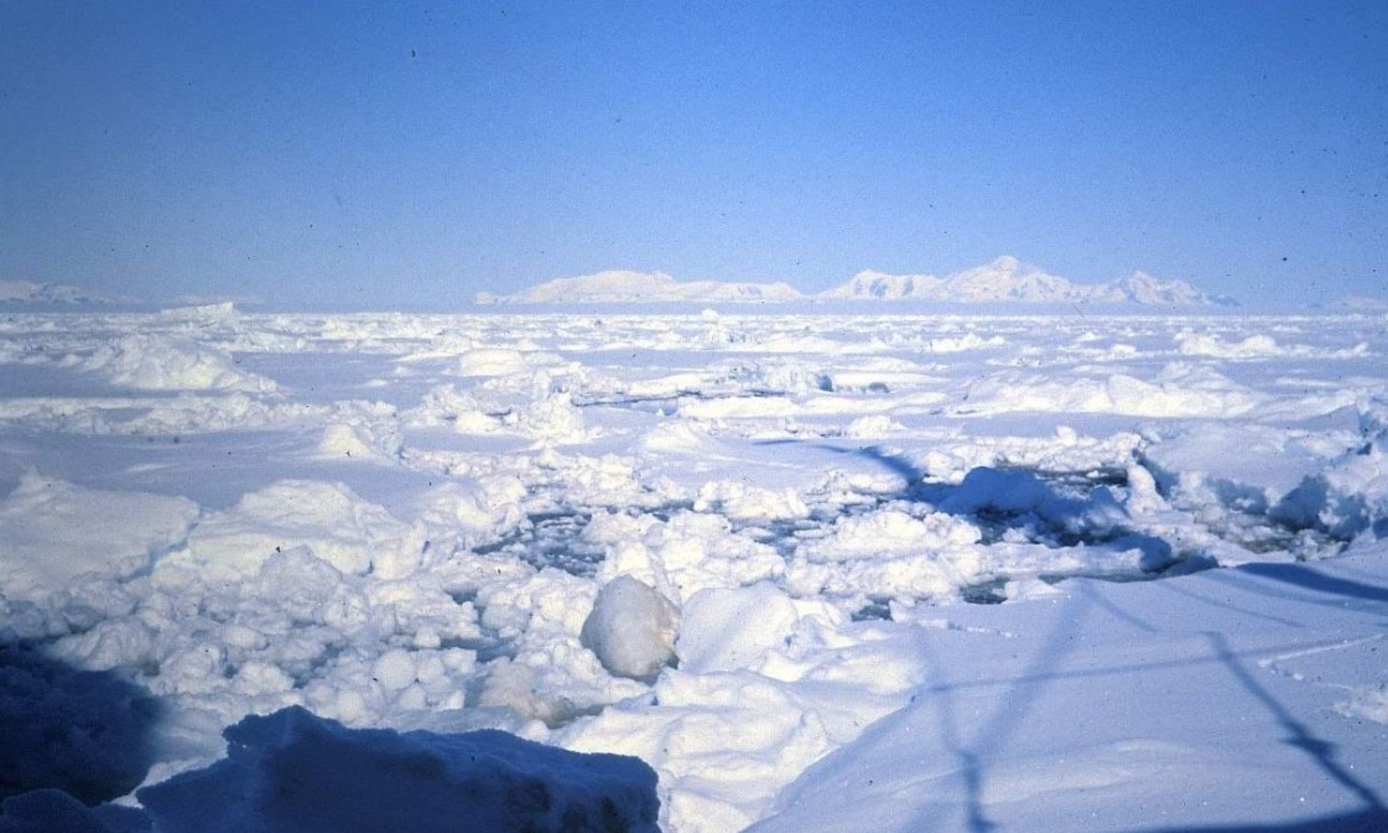
For this trip I was accompanied by Robin (Rob) Davies, Adelaide GA and BC, who flew in later on the 13th, and after finishing loading FAP and FAQ, the twin otters flew “Sledge Delta” to Rothschild Island, off the northwest coast of Alexander Island, at the southern margin of Marguerite Bay. I have relied heavily on Rob’s travel report for this account, excerpts, and FID terms from which are included in parentheses.
The first reported sighting of Rothschild Island was made by Thaddeus von Bellingshausen in 1821 during his voyage past the NW coast of Alexander Island. He described three mountains separated by gaps, which are now identified from west to east as Mirnyy peak (Rothschild Island), and St George Peak (Havre Mts) and Mt. Bayonne (Rouen Mts) in northern Alexander Island. A closer view of the island was obtained by Charcot during the 1908-1910 French Antarctic Expedition who named it in honor of Baron Edouard de Rothschild, financier, and head of the Rothschild banking family of France. Following misleading aerial explorations during the BGLE (1934-1937) which suggested the island was part of mainland Alexander Island, its insularity was finally recognized during a 1940 flight by the USASE and verified by RARE flights from 1946-1948. The first personnel to actually visit the island were the BAS survey team of Richard Barrett (surveyor) and Mike Chantrey (GA) who were flown in to establish survey station “Rothschild” in the south of the island on 3rd January 1976, but we were to be the first team to extensively travel and map the geology of the island by land in November and December of 1976.
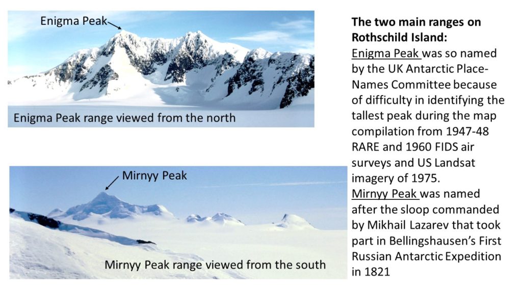
Our hopes of an aerial reconnaissance of the island before landing were thwarted by an almost 100% ground mank and so we landed in the only clear spot, between the Enigma Peak and Mirnyy Peak ranges in the north of the island, and established our 1st campsite by midnight on 13th Nov.
The following morning started with low cloud and white-out conditions, so we spent the time sorting our gear and formulating a plan of action as we had had no time together before our flight to do so. A quick recce during clearing conditions later in the day revealed conditions to be “quite travelable with several accessible rock stations.” However, poor weather conditions kept us tent-bound for most of the next five days with only two clearances allowing the outcrops along the eastern ends of the Enigma and Mirnyy ranges to be examined.
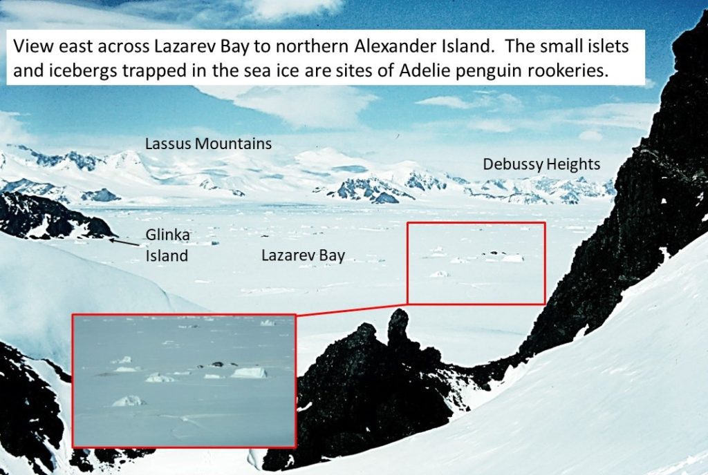
Blowing and drifting snow early on the 20th Nov cleared by 9:30am enabling completion of the remaining work on the ranges as well as access to isolated nunataks bordering Lazarev Bay, which afforded splendid views eastwards to the Havre and Lassus Mts in NW Alexander Island.
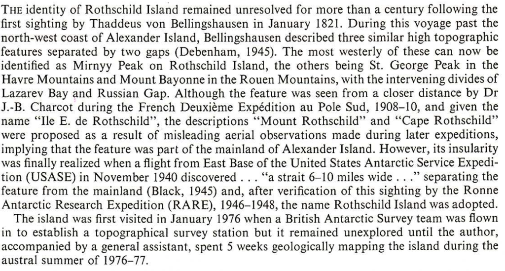
I should note here that in contrast to the 2022 satellite image shown above, the entire Lazarev Bay and area to the north of Rothschild Island was covered by fast ice in 1976/77 and there were isolated penguin rookeries on the sea ice and small islets to the south of Glinka Island.
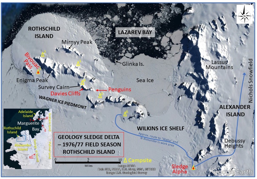
We established our 2nd campsite by 3:00pm the following day at the northern end of the Enigma range after travelling 15 miles in “deep softer” conditions in 3 hours. We then finished the day “empty-sledging“ (one skidoo and one un-laden sledge each) along the northern side of the Mirnyy range. After a day’s lie-up due to blowing snow and white-out conditions the geological sampling of Mirnyy and Enigma ranges was completed and on the 24th Nov our 3rd campsite was set up at the southern end of a northwest-southeast pass separating the westernmost ridge of the Enigma Peak range from a paralleling un-named ridge to the west. Rock exposures in the pass were visited on the 25th Nov before FAP flew in at midnight and picked up some rock boxes.
Weather conditions started to deteriorate the following day – “ Lie-up, blowing, snowing, drifting and gusting 50 kts” – but had improved enough by the 27th Nov to finish off the remaining geology from our location. That night the wind began increasing and gusts became more frequent, and at 01:08am on the morning of the 28th Nov, our campsite was subjected to a particularly strong gust estimated to be in excess of 100 kts which resulted in the tent being blown down and the ground sheet and its two occupants ending up about 4 yards downwind in the open still in sleeping bags surrounded by most of the tent’s contents, although my P-bag, lilo and Zdarsky Sack were nowhere to be found. After dressing and securing all loose items, we dug a snowhole and retired for a mostly sleepless night in Rob’s Zdarsky Sack.
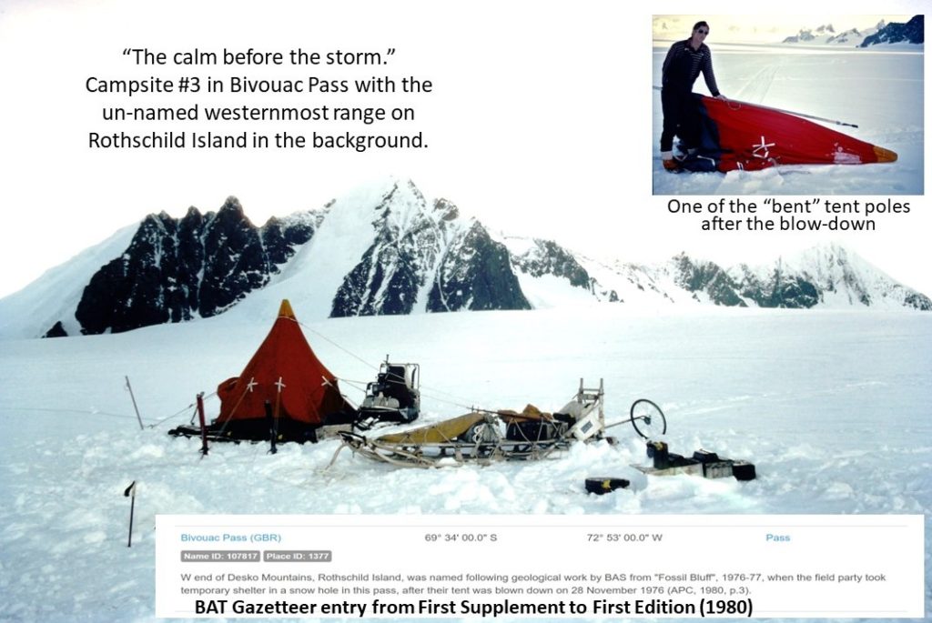
Somehow our “Squadcal” radio was undamaged, and we informed Rothera of our plight during the 8:00am sched. By 10:00am the wind had eased sufficiently for us to re-pitch the tent. The poles were bent and the inner ripped, but the outer appeared undamaged. FAP flew in at 10:30 that evening with a replacement tent and other requested items, and we were able to get some sleep in the old tent with the wind still gusting but now only about 30 kts. The detailed incident report is included below.
The wind continued to abate on the 29th and by 4:30pm we had packed up camp and moved off to our 4th campsite in the snowfield just north of the Rothschild survey station. The next three “dingle” days saw much of the geology work in the vicinity completed including a move to our 5th campsite in a col to the southeast of the survey station ridge. Geologizing stopped on 3rd Dec for a week due to low level mank covering most of the southeast of the island and preventing travel to the remaining rock exposures. It was during this time that we learnt that FAP had damaged a ski and could be out of commission for a while, although this had no effect on our immediate plans. Conditions improved sufficiently on 10th Dec enabling us to resume work and the next morning we visited an isolated nunatak about one mile south of the island on the Wilkins Ice Shelf off the southeastern margin of the Wagner Ice Piedmont. “Descent onto the ice shelf caused no problems with only the occasional hole that was easily circumnavigated and several slots that were seldom more than 6 inches wide to cross”. In the afternoon we deposited the damaged tent and three rock boxes at a depot at the eastern
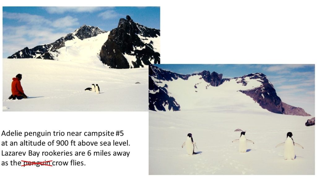
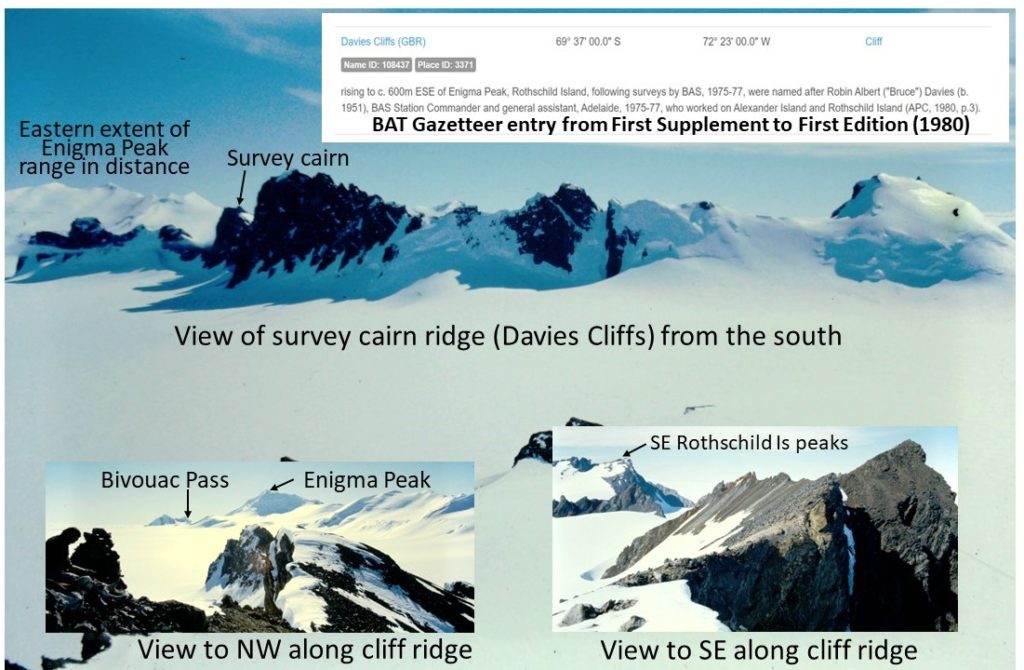
end of the survey cairn ridge, where we came across three adelie penguins at an elevation of about 900 ft above sea level and 6 miles from the rookeries we had seen previously in the fast ice to the south of Glinka Island in Lazarev Bay. The penguins followed our tracks back to the campsite eventually arriving just as we had packed up everything and were heading off to our 6th and final campsite in the southeast of the island. This was reached by travelling around the southern side of the survey cairn ridge to avoid “a band of holes extending northeast from the eastern edge of the ridge for the whole width of the drop-off leading down to Lazarev Bay”. The names “Davies Cliffs” and “Bivouac Pass” which I formally proposed for the survey cairn ridge and the snowfield at the western end of the Enigma Peak range (where we had the tent mishap) were approved by the Antarctic Place Names Committee in 1978 and 1979, respectively.
On 14th Dec, after completing all but a handful of accessible outcrops we were asked by Steve Wormald (Summer Field Operations Manager at Adelaide/Rothera) on the 7:30pm radio sched to terminate further work on Rothschild Island and sledge across the Wilkins Ice Shelf to check on Sledge Alpha (Rick Burn-geologist and Rick Atkinson-GA) who had been out of radio contact for the past 3 days whilst working in the Lassus Mts in NW Alexander Island. Weather conditions prevented us travelling until the 17th when at about 11:00am after de-camping we made an uneventful descent onto the Wilkins Ice Shelf and headed southeast towards the southernmost pass in the Lassus Mts. After “crossing a few holey areas associated with isolated ice rises we encountered a series of well-bridged holes as we crossed the final mile onto the ice piedmont of Alexander Island” and sited the Sledge Alpha campsite, further south than expected. We joined them around 2:00pm, to find they were OK, but their radio battery had died. Rob spent the next day helping them wire-up a temporary power supply using their two skidoo batteries, and, on the 19th Dec, we departed northwards in Alpha’s skidoo tracks for the Nichols Snowfield to commence the second phase of our geology program in the Havre Mts (and finish off the work I had started there the previous field season).
Rothschild Island Geology Survey Trip statistics
Days in Field 35 days (13 Nov to 17 Dec 1976)
16 days lie-up (46%)
15 days geology (full and partial days) (43%)
4 days travel only (fly in/campsite moves/sledge off) (11%)
Bernie Care (Geologist: Stonington 1974/75, Adelaide and Rothera 1975/76 and 1976/77)