(Header Photo: Rod Pashley)
History
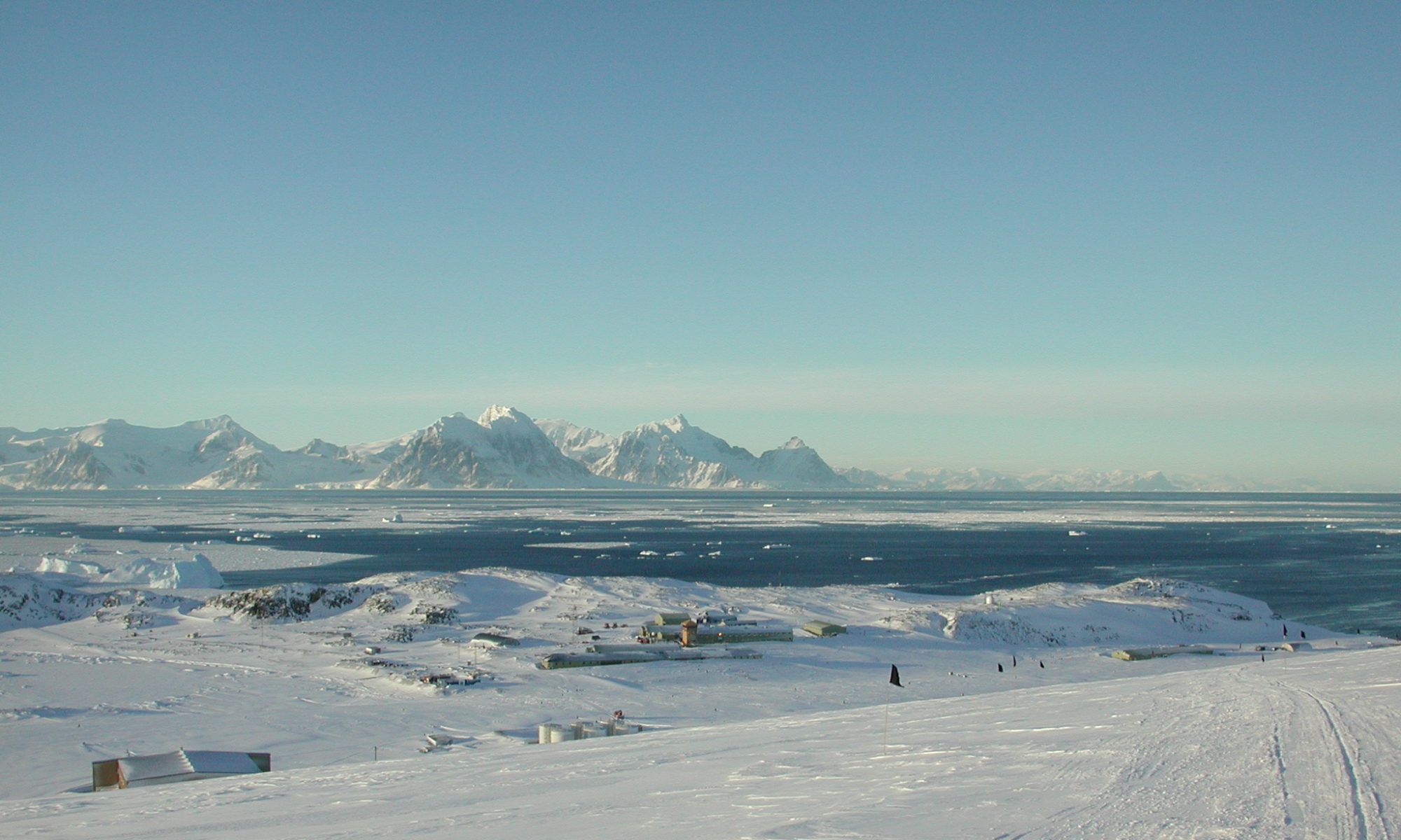
Horseshoe is 12 km (6.5 nmi) long and 6 km (3 nmi) wide occupying most of the entrance to Square Bay, along the west coast of Graham Land. It was discovered and named by BGLE under John Rymill who mapped the area by land and from the air in 1936–37. Its name is indicative of the crescentic alignment of the 600 to 900 m (2,000 to 3,000 ft) peaks which give a comparable shape to the island.
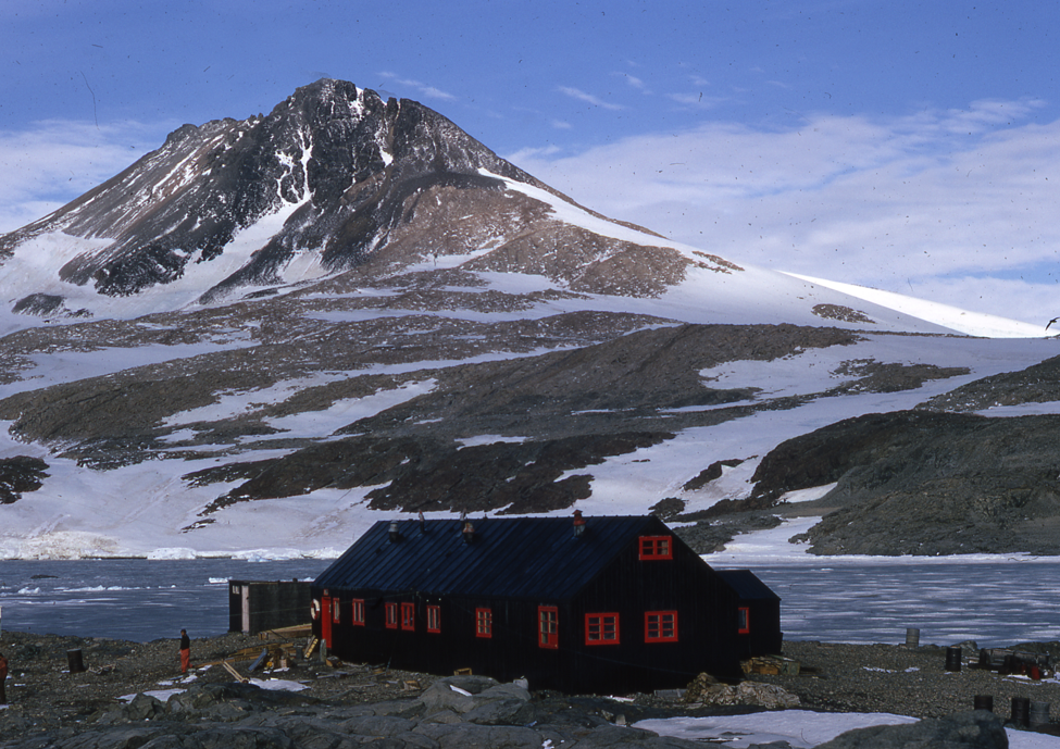
Horseshoe (67°48’S, 67°18’W) was established as a scientific base in March 1955 and closed in August 1960 when operations moved back to Stonington. Research carried out here included geology, meteorology and topographic survey. Extensive survey trips covering hundreds of miles and lasting several months were undertaken from the base using dog teams and sledges.
“Horseshoe” includes ‘Blaiklock’, a nearby refuge hut. The site has been designated a Historic Site or Monument (HSM 63), following a proposal by the United Kingdom to the Antarctic Treaty Consultative Meeting.
Winters:
1955
Base Commander – Ken Gaul
| Y | Atkinson, D. (Donald) | DEM |
| Y | Exley, J.A. (James) | Geologist |
| Y | Farquhar, G.A. (Gordon) | Radio Operator |
| Y | Gaul, K.M. (Ken) | BL, GA |
| Y | Kemp, B. (Brian) | Meteorologist |
| Y | Searle, D.J.H. (Derek) | Surveyor |
| Y | Taylor, R.D. (Richard) | Meteorologist |
| Y | Vine-Lott, G.T. (Trevor) | Meteorologist |
Topographic Survey
1955-7 Derek Searle
A new base was established at Horseshoe Island in March 1955 but poor sea ice in 1955 and 1956 curtailed activities. Derek Searle produced a 1:25,000 detailed map of the island for the geological work. He recced a route up on to the plateau and another northwards. From a sun-fix at base and a baseline measured on the sea ice, a small triangulation scheme was beaconed and observed on the NW of the island and extended eastwards.
A new field hut was erected on Blaiklock Island for further work.
‘The Admirals’ – Jim Exley
This FIDS/BAS team is accepted as having had the longest existence. They carried out the last journey, before being transported to Hudson Bay, only to suffer a sad fate, with the death of most of the dogs, from disease. There seemed to have been 16 regular drivers after 1958, and at least 3 before that date. In view of the policy of allowing all on a base to have at least some sledging, I would guess that well over 100 have driven the team, if only under the eagle eye of the regular driver. I am sure that many must have wondered about their earlier history, as I have – here is what I know.
Lost Travelers – Jim Exley
1956
Base Commander – Derek Searle
| Atkinson, D. (Donald) | DEM |
| Chalmers, D. (David) | Meteorologist |
| Cumming, G.C. (Geoff) | GA, Builder |
| Donnelly, A.K. (Andrew) | Radio Operator |
| Evans, M. (Malcolm) | Medical Officer |
| Exley, J.A. (James) | Geologist |
| Ryan, F.B. (Frank) | Meteorologist |
| Scotland, C.D. (Cecil) | Meteorologist |
| Searle, D.J.H. (Derek) | BL, Surveyor |
| Vine-Lott, G.T. (Trevor) | Meteorologist |
An Antarctic Holiday – Manhauling – Don Atkinson
(Originally written for the Fell & Rock Clmbing Club, supplied by Rich Atkinson, Don’s nephew)
Travel in the Antarctic need not always be a grim fight or a monotonous routine. There are times in the spring, for instance, when skies are cloudless and blue for days on end and no breath of Wind stirs the air; one can ski almost effortlessly along with the sledge on superlative snow surfaces, and it is possible—even preferable—to travel in shirt sleeves, although the thermometer may insist that there are more than twelve degrees of frost. It is on days like these that the sensationally beautiful islands of multi-coloured rock and ice appear at their best when viewed across the intervening miles of frozen sea. The impregnable barrier of ice cliffs that flanks more than nine-tenths of the coastline of Antarctica, and the icebergs, still locked in the grasp of the sea ice, show off their incredible range of blues and greens. These ethereal colours illuminate the shadows in the depths of caves and fissures, and etch the outlines of towers, pinnacles and battlements of infinite variety and complexity, defying the memory to forget. Surely this carving of ice is the most wonderful of nature’s sculpture.
The departure of Malcolm, Cecil and myself on a five-day reconnaissance journey in early July was attended by the great promise that these conditions imply, even though this could scarcely be termed a spring journey. But, though the sun still lay a little below the horizon, we thought of this trip as our holiday from base routine and a welcome contrast to the sterner business of long sledge journeys.
1957
Base Commander – Percy Guyver
| Fellows, J.W. (James) | Meteorologist |
| Gibbs, P.McC. (Peter) | Surveyor |
| Guyver, P. (Percy) | BL, DEM |
| Imray, H.A. (Sandy) | Medical Officer |
| Larmour, G.M. (George) | Meteorologist |
| Maloney, L. (Len) | Meteorologist |
| Procter, N.A.A. (Nigel) | Geologist |
| Roberts, B.R. (Bryn) | Radio Operator |
| Rothera, J.M. (John) | Surveyor |
Topographic Survey
1957-8 Gibbs and Rothera
Based at the Blaiklock Refuge Peter Gibbs and John Rothera worked north into the Arrowsmith Peninsula between them and Detaille Island and west to Laubeuf Fjord with chains of triangulation and a 20 star astro-fix at Blaiklock.
Sledging Reminiscences in Marguerite Bay – Peter Gibbs
When Bill Sloman asked me at my interview for a job as a surveyor with FIDS “Have you got any experience in handling dogs?” “Yes” I replied “I have trekked and canoed with Bull Terriers in southern Africa and we took one down the Orange River”. “Did you revise the maps as you went?” asked Denis Wiggins. “No”, I said “but we noticed the errors!”.
I am sure it was the first question that got me the job. A love of dogs, and ability to communicate with them, share with them good times and bad times, laugh with them, be firm with them yet forgive them if you can when they have run circles right around you; these were essential qualities in the succeeding generations of FIDS dog drivers. And if you had these qualities they rewarded you manifold not only in getting journeys accomplished but in raising one’s whole level of appreciation of the Antarctic experience. The character of the husky exemplified the characteristics that some of us aspired to attain but were often found wanting – extreme patience and endurance in miserable conditions and a love of hard work for no reward but its own sake until it drops in its tracks. The expression of patience, joy and zest for life shown by fit huskies at the sight of a bunch of harnesses, barking and straining to be off, in effect saying “Come on, Life is Great, God’s in his Heaven, Lets Go!” affected us equally. Like many others I am personally deeply indebted to the dogs I shared two years with. And I wonder too on how many countless occasions Base Leaders and others with deep problems and decisions to make would counsel their favourite dog and get the answer they wanted. To me it is a great sadness that the sledge dogs’ day in BAS is over. I hope that this will contribute to their fond memory and record their invaluable help to us in our life and work.
Peter Gibbs – Surveyor – Base Y – Horseshoe 1957; Base E – Stonington 1958
A Second Year, at Horseshoe Island – Jim Fellows
Extracted with the Kind Permission of Jim Fellows, from his book “The Story of Jim” (Austin Macauley Publishers). Jim first wintered at Deception Island, before being transferred. He lost all his colour films of their activities including sledge journeys, as he explains later in the story, so there are no graphics.
The Royal Yacht (Britannia) sailed away (from Deception Island Base), the excitement was all over, and it was back to work for everyone. Not that work routines had really stopped, weather observations and radio schedules had to be done, royal visit or no royal visit. With the royal visit over, our attention was then focused on our new bases, I say bases because not all of us were going to the same base. Angus Erskine was to be base leader of the new Base W, which had been established on Detaille Island; John Smith was also headed for Base W. From there, surveyors hoped to be able to get on to the top of the Antarctic Peninsula, as well as the north side of the Arrowsmith Peninsula. Colin Johnstone would be going to Hope Bay, Base D, and Jack Hill was off back to UK. That left Len Maloney, myself and Percy Guyver headed for Horseshoe Island Base Y. Percy Guyver was to be base leader, and Peter Gibbs, John Rothera, Sandy Imray, George Larmour, Nigel Proctor would join us and with Bryn Roberts, our new radio operator, would make up a team of nine.
Waiting for your relief team is probably the most stressful time on base. There was the writing up of reports on all the activities of the team over the previous 12 months, the goodbyes to comrades and companions from the previous 12 months. Then welcoming the new team and helping them get settled in and, of course, helping unload their stores and supplies for the coming year was all part of finishing our stay at Base B, Deception Island.
Blaiklock Refuge – Peter Gibbs
When the John Biscoe landed me with Nigel Proctor and John Rothera at a refuge hut on Blaiklock Island on the 6th March 1957, we were without dogs. Our work lay in the Arrowsmith Peninsula connected by the Jones Ice Shelf. The previous two years of the Horseshoe Island base had been such mild ‘open water’ years that very little exploratory sledging could be done. We could at least start the survey program by man hauling and get dog support when the Bourgeois Fjord froze. The weather gods blessed us as regards colder conditions to freeze the fjords so that on 15th June two dog teams, the Admirals and Churchmen, made the 21 mile journey up from Horseshoe, the Admirals driven by Dr Sandy Imray, who happily, was to be my sledging partner for the rest of the season.
The first days sledging back to Horseshoe, one week before midwinter, was a memorable experience. We had been joined by Angus Erskine and Jim Goldring who had found a route from Base W up the Plateau and down the Finsterwalder Glacier with their two teams and were coming down to Horseshoe for a visit. So there were four sledges in line ahead with the temperature -28F and a fast surface, the Horseshoe teams knowing that they were going home and leading a good pace, I skied and jogged keeping company with different drivers. In the 4 hours of twilight we reached base, colder but faster than manhauling. This was the first of about 372 days sledging in these two seasons which covered some 2090 miles with the Admirals. About half of this was on sea ice and half on inland glaciers. Caesar was the lead dog all this time and must be ranked among the finest of lead dogs. At the end of our summer journey from Stonington in the second year I wrote that this journey with three men and three dog teams was only possible due to Caesar’s ability to lead out front. He developed precise direction change according to the volume of tone of “Huit” or “Irr” and took account of the sledge distance when circumventing obstacles or crossing leads and crevasses. Caesar was loved by Babe who ran first pair but on a slightly longer trace than Johnny.
Mountaineering With Dogs – Peter Gibbs
Sandy and I, both keen mountaineers, enjoyed the task of placing trig station markers, cairns, barrel or guyed flagpoles on the chosen summits of the Arrowsmith Peninsula, and then observing from them. We used a small team of 3 or 4 dogs pulling a 6′ ft Nansen to assist us get equipment up the mountain wherever possible. One photo shows Caesar, Babe, John and Buster returning from an ascent up ‘Barrel’ Mountain.
These inland glaciers were all crevassed but thanks to providence we had no bad accidents and many lucky escapes. On the 12th October sledging down Whistling Bay Glacier, we stopped short of two wide sunken bridged crevasses on a steepish bit of downslope while I took out the survey photographs to prospect a better route. While both of us were preoccupied the dogs pulled the picket and went straight on across before I could overturn the sledge. They were some 30′ wide. On the Heim glacier I probed a similarly wide crevasse. It held and we sledged across and the next moment it collapsed with a swoosh behind us. All this season the two of us were sledging with the one sledge which invites more risk that two with two sledges. Several times individual dogs fell and were pulled out by their traces. We were grateful to Angus Erskine, who from his Greenland experience, introduced some modification to the harness which secured the dog safely when hanging. We always ran centre trace but the side traces were made at least 2 metres long so that a dog had ample space to hang back and jump over a crack. An average of 3 harnesses could be made out of one roll of 2″ lampwick.
The Calibration Game – Peter Gibbs
For the triangulation scheme we measured a base line on the sea-ice in front of the refuge hut. Frequently I was called on to calibrate a sledge wheel. The dogs got to know this and thought it was a great game invented for their enjoyment. The line between the baseline terminals had to be straight so the first track was made walking in a straight line ahead. Then the dogs knew that it was their turn for the rest and several more runs. As the wheel was carefully picked up at the end of each run they described a circle with mounting excitement to dash back down the trail with tongues out and laughing chaps.
Fun Times – Watch the Bonker! – Peter Gibbs
Local sealing outings from the base station or refuge were a means of exercising and training dog teams as well as necessarily getting in a supply of seal meat. When one appeared with harnesses in hand the dogs yelped in anticipation on the span trace wildly impatient to be in harness. Dog fights would all too easily break out during the interval of leading harnessed dogs from the span trace to the picketed dog trace. A dog driver preferred the assistance of a second to stand on the centre trace and pretend to be in control by blasphemous threat as to what he would do with his “bonker” (length of back-spliced rope) if any dog usurped his authority. Too often this was wishful thinking.
Some dreadful fights took place and one I experienced underneath the pack and definitely not in control. It was the 16th September ’57 at the refuge hut. Sandy had harnessed them up and we were off to collect in 3 seals from Fidge Island killed the day before. Something confused Caesar who refused to lead out onto the ice and turned back towards the hut where the Churchmen were picketed. I ran forward to lead him away but not before a fight broke out between the two teams. I waded in to separate the main protagonists Wol and Monty and my feet slipped on the glare ice.
When standing you have some supposed authority but when lying prone under 9 snapping huskies you are in a dangerous situation. I could not immediately get up because Wol had me by the knee and was shaking his head and me with him as if to say ‘Thanks sport now its my turn!’ When it all calmed down he licked my face to say he didn’t really mean to hurt me. It gave Sandy a rare opportunity to practise deft surgical skills with many sutures, and delayed our sledging together for a few days.
Peter Gibbs – Surveyor – Base Y – Horseshoe 1957; Surveyor/BC – Base E – Stonington 1958
1958
Base Commander – John Paisley
| Black, S.E. (Stan) | Meteorologist |
| Hillson, R.H. (Richard) | Meteorologist |
| McDowell, D.W. (David) | Meteorologist |
| McGowan, E.R. (Ray) | Radio Operator |
| Paisley, J. (John) | BC, Meteorologist |
| Statham, D. (David) | Meteorologist |
| Stride, G. (Geoff) | Meteorologist |
May 27th – A Tragic Journey – John Paisley – Base Commander
Stanley Black, David Statham and Geoffrey Stride left Horseshoe Island on the 27th of May 1958 with two sledges and teams of seven dogs on each.
David was in charge of dogs on Horseshoe Island. After initial training of the teams, both were used to collect depots from Engelm Glacier and Ridge Island. David also used his team to visit Stonington Island between the 18th and 21st of May. Sea ice was complete with even snow cover. The lead dog in David’s team was Sneaky with Yeti and Eccles, Alma and Corky then Visca and Bessie in pairs behind.
Stan’s team leader was Ruth with Angus and Major, Coco and Yana, Chloe and Umiak as following pairs. Both teams had completed about 150 miles of journeying before the 27th. Stan’s sledge carried all the equipment to be used en route (568 Ibs) and left at 11.30 local tune. David accompanied by Geoff left at 12.00. Their sledge carried equipment that was to be left as a depot on the Dion Islands. (715 Ibs).
At 13.15 observation from Flagstaff Hill showed both teams running well; Stanley Black had maintained his lead and was approximately one mile from the ice cliffs at the south end of Pourquois Pas Island.
The first camp was planned to be at Cape Bongrain or inside Dalgliesh Bay – a total distance of fourteen miles from Horseshoe Island base. When last seen the parties had covered about one third of this distance with three hours of travelling light remaining.
At Base, wind records showed a steady increase from 2 kts. at 1500 hrs to 31 kts. at midnight and 45 kts. at 0300 on the 28th, at first from the East, then backing to N.E. and remaining strong throughout the day. There was no radio contact that night. As anxiety increased other Bases were alerted for listening watch. The first occasion visibility allowed observation was the morning of the 30th. All the sea ice had gone.
Return of the dogs:
June 6th Yana returned with harness complete without clip hook ring.
June 13th Chloe was found by Peter Gibbs on Millerand Island. She had been there 6 days and the Argentineans had removed her harness.
June 15th Alma arrived back at Horseshoe. No harness.
June 17th Ruth and Angus turned up at Stonington. One harness complete one without codline or ring.
June 21st. Coco and Umiak found by Peter Gibbs and Dave McDowell on islands between Horseshoe Island and Camp Point. Coco’s harness badly chewed, back straps and cod fine missing. A clip hook and small piece of side trace attached to the collar.
June 28th. Corky and Bessie returned to Horseshoe minus harnesses.
July 2nd Eccles returned to Horseshoe having been seen the day before in Lystad Bay. No harness.
All dogs were in good condition with no injuries and little icing up. Ruth and Angus had put on weight, neither exhibited any nervousness. That these two dogs were seen on the Debenham Islands and evaded capture was attributed to the presence of the Argentineans. No message was found on any collar.
John Paisley – Base Commander – Horseshoe Island
Further note in longhand. In the story of the return of the dogs it is important to emphasise that: 1) the dogs were well trained and practised. 2) both Stan and Dave had their own teams. 3) the sea ice was well established and had been there for about a month and had been travelled over by both men previously. 4) the weather was actually as given particularly as regards wind speed.
10 dogs out of the original 14 returned to be fitted into other teams. Very little can be gleaned from the state of the harnesses as to whether they had been released by the three men when they realised all hope of survival was gone or chewed their way out. The way the dogs returned to their various points of recovery gives no clue either about where the men were lost.
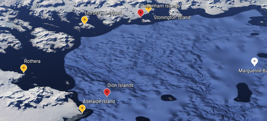
(Note by Kevin Walton) Problems with sea-ice were always unpredictable in the Marguerite Bay area and especially in the channel between Adelaide Island and the mainland. It was in these parts that John Rymill in his second year had to abandon their motorised sledge with all their stores and run for it in midwinter on a depot-laying journey. Six of their wintering party were lucky to escape with their lives. The stories of sea-ice travel in and around Marguerite Bay could form a book on their own.)
Horseshoe Island Yarns – John Paisley
‘The Krodats’
(This story was in reply to my query. At Stonington we had our own brand of Gremlins who could be blamed for anything that was lost or went wrong. At Horseshoe base they appeared to be well established as “Krodats” and I asked John Paisley to tell me more about them – Kevin Walton)
You asked about the Krodats. They existed before our arrival; they were an inheritance as with all else at Horseshoe Island. There was no moment when we first saw them, we just accepted them and no-one ever explained the “Krodat” lights that we saw on Pourquois Pas Island. On occasions they were in a cluster, at other times they were a row of lights looked like a column of men wearing head torches. On very still nights we would go out and watch these strange phenomena. The dogs were quite indifferent to our interest.
Should anyone doubt that “Krodats” were real I have a letter sent to me by John Rothera sent by “Krodat Post”
The Chorus
In conditions of absolute calm it used to happen. Empty fuel drums began to resonate as did aerial masts and wire rigging. That was a very special time; the air became filled with a penetrating but low pitched hum. We were not the only ones to be affected at such times. The pups, running free, used to wander up Flagstaff Hill, sit down and with heads back howl in long harmony. My picture shows the pups in operation at that special time when blueness filled the air and all distance became foreshortened. The view here is across Bourgeois Fjord and on to Camp Point and Pourquois Pas, all of seven miles.
The Episode
Peter Gibbs and I were camped on the Dion Islands. Ours was the last and furthest out of the many long search journeys. The sea-ice was measured as 12 inches, conditions very calm and the temperature very low -50 F.
As inside man my job on waking was to light the stove to prepare breakfast. The stove was always lit with great caution so that its heat would ablate the web of ice crystals back to the tent walls. Once this was done I sat up and put a mess tin of snow on to melt for porridge.
Sitting there I saw my Mother come into the tent. She told me that she knew how worried we were but if we set off at first light all would be well. I woke Peter up and over breakfast told him that I thought that we should set off for home immediately. After all our worries on the previous evening he was not a little surprised. I remember only one troublesome ice lead on the way back when the dogs ran wonderfully. When we were within safe reach of Horseshoe I told Peter what had happened in the tent. We did not talk about it again
John Paisley – Deception BL/Met. 1957, Horseshoe – BL/Met. 1958
1959
Base Commander – Robin Perry
| Franks, J.L. (James) | Meteorologist |
| Hoskins, A.K. (Keith) | Geologist |
| Hunt, J.M. (Malcolm) | Meteorologist |
| Malden, J.F. (James) | DEM |
| Mallinson, G.D. (Gordon) | Radio Operator |
| Perry, R.M. (Robin) | BL, Meteorologist |

A Midwinter Guest – Robin Perry

A few days before the feast of Midwinter a strange dog was noticed creating a hullaballoo among the teams out on our spans. I had no difficulty in recognizing Steve. He had been on the loose for nearly three months and seemed pleased to find people again. I attached him among ‘The Spartans’ where he was not exactly well received at first! We found he was a good 20lb (10kg) above his normal weight, and in excellent form.
He must have gorged himself on the Base W seal-pile for a while, then felt the need for the company of the pack. He had done the journey from Base Y to W the previous year, so that may have helped him find his way over the glaciers and sea-ice. The distance had he been able to fly like a crow is about 70 miles (110km).
August – Journey Diary – Horseshoe to Stonington – Robin Perry
Tuesday 18 August Malcolm and Keith returned, accompanied by three Argentinians: Teniente Gustavo Giró, Sergeant Verón and Corporal Alfonso (with two sledges, each with eleven dogs). It was decided that Keith (with the ‘Admirals’) and I (with the ‘Spartans’) would return with them to San Martín on or around Sunday 23 August.
Sunday 23 August Got up to do 06.00 observation, but it was overcast with poor visibility and light snow. Nobody else was around which was a relief as I could finish my preparations and bring the met. statistics up to date. Malcolm was base cook.

Monday 24 August Light air from SSW but clear, so got ready to leave. Gordon first with the ‘Folies’, then the Argies, and finally Keith and I left at 11.00 with the usual brawls to sort out dog hierarchy and span grievances.
We all reached Lagotellerie Island about the same time. Gordon then returned to base. We took on an extra six dog-food boxes for the Argies, but one dropped off as we departed and was left. We had no really good lead dog between us and, after a period of trials with Pooka, Keith asked if one of the Argies could ski up front, whereupon we made fairly steady progress on rather bad surfaces. It was now calm and the only cloud was a sheet of cirrostratus low on the western horizon which, as was to be expected, increased during the afternoon
October – Journey Diary – Horseshoe to Detaille Island – Robin Perry
Saturday 10 October – Overcast with nagging NE wind and very light snow as we departed at 10.30: Gordon, then Keith then me. Surface excellent, like a main road, and the wind soon dropped. Very good progress to Ridge Island where we had a pause. Some trouble getting Ruth to proceed, and Alpha got off after sustaining a going-over by his mates. Beyond Ridge Island the surface became more uneven with patches of bare ice showing; low drift was occasionally raised by gusts from valleys to the SE. As we progressed, higher drift became evident blowing out from the entrance to the Jones Ice Shelf, and later down the face of Blaiklock Island, so we pulled up on to Gnome Island as the first gusts arrived at 16.45. The tent was erected in a gale-force wind coming straight down the mountain face to the NNW, and soon the drift was compounded by moderate snowfall. The teams were picketed in hard névé. We had travelled 21 miles (35km).
Sunday 11 October – Continuous moderate snow with drift, later the NNW wind died down, but the snow was relentless. Babe was found by Gordon to have pupped. The 119 radio refused to function, so we decided to dump it here.

(Photo: Robin Perry)
Monday 12 October – The sledges were buried under a Christmas card snow scene. The sun was shining, though clouds were moving fast from the WSW. After the shovelling session we got away at 11.30, the going was rather heavy at first, but improved around the east cape of Blaiklock Island. The surface became excellent once on the ice-shelf where we had a lunch stop at 13.15. Still sunny, but thickening upper cloud. No cracks were seen until we turned right up the Heim Glacier. At about 200 ft (71m), Gordon stopped at a series of crevasses, so we picketed, intending to reconnoitre, but the NNW wind increased, raised drift and brought continuous wet snow. Therefore after circumspection camp was made at 15.00. Only seven miles (11km).
March 1960 – Relief
Thursday 17 March When I got up I learnt that Ron Lord in the Otter was taking off from Deception, and a further sked was arranged at noon to check on our weather. So I shaved (!) and we all made some last-minute preparations. It was cloudy with a few patches of low stratus and temperature 29°F (–2°C). There was some concern when the Otter’s engine suddenly stopped near Brabant Island, but luckily the interruption in the fuel supply was easy to rectify and the aircraft landed safely at the Biscoe at 11.10am.

(Photo: Robin Perry)
At that moment we had a heavy shower of snow, but by sked time it was clear again and Paddy English announced his intention of coming on down at 3pm subject to a weather check at 2pm.
I was not very happy about our weather; nimbostratus seemed to be thickening to the north and the movement of the cloud sheet was from there. Paddy took off on time and it began to snow on us. After informing Paddy about this via Biscoe and Kista Dan I sent the routine weather observation to Stanley and then tuned to the aircraft frequency 4040kHz. The snow became heavier and visibility deteriorated, but Paddy pressed on. So at 4.20pm I had to send Gordon and Jim M to the airstrip. At about that time Paddy went out of radio range of Kista Dan and I could not hear him either. However, at 4.50pm he was reported to be at Liard Island and estimated arrival here at 5.10. Five minutes later he announced that he was turning back.
Epilogue – A Nutty Story
Read about the consequences of receiving women’s magazines here
1960
Horseshoe Base Commander – Peter Forster
| Davies, A.G. (Antony) | Medical Officer |
| Forster, P. D. (Peter) | BL, Surveyor |
| Grimley, P.H. (Peter) | Geologist |
| LeFeuvre, C.F. (Charles) | Radio Operator |
Topographic Survey
1960-1 Forster at Stonington Island and Horseshoe Island
Heavy sea ice prevented access to Stonington but in Feb 1960 a party of 4 was flown into Horseshoe Island. Peter Forster mapped areas of Bourgeois Fjord and Square Bay not covered by air photography. The party then moved south to Stonington. Exploratory surveys were carried out between 68.5s and 69.5s the survey linked to work by BGLE 1936 and down the Lurabee Glacier to work by Mason 1947
1965
(Partial year while based at Stonington)
| Matthews, D.W. (David) | Geologist |
| Vaughan, D.N. David) | Tractor Mechanic |
| Steen, J.W. (Jim) | GA |
1969
| Rowe, Pete | Geologist |
| Flavell-Smith, Ian | Geophysicist |
| Burns, Mike | Geophysicist |
| Sykes, Ian | GA |
July 19th – Jones Ice Shelf and The Moon
Added with the Kind Permission of Ian ‘Spike’ Sykes from his book “In the Shadow of Ben Nevis” (available on Google Books)

In 1969, on my second year working for the British Antarctic Survey, four of us reopened the old disused base on Horseshoe Island. Myself as the General Assistant with my dogs (The Vikings), Ian Flavel Smith (Geophysicist) with his team (The Komats) and Mike Burns (Geophysicist) and Pete Rowe (Geologist) were taken by the ‘RRS John Biscoe’ from our main base on Stonington Island to spend the winter doing geophysics before setting out south for the spring journeys. Horseshoe Island is in Marguerite Bay, about halfway down the West side of the Antarctic Peninsular just south of the Antarctic Circle.
The ‘Biscoe’ left the four us waving goodbye from the beach among a pile of boxes. Ali MacArthur