
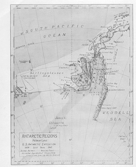
The History of Surveying in Marguerite Bay
Exploration of the Marguerite Bay Area prior to 1944 – Richard Barrett
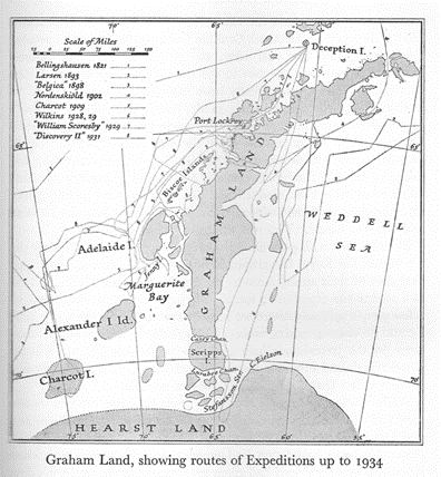
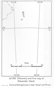
On 27 January 1821 Admiral Fabian Gottlieb Thaddeus von Bellingshausen, a Russian naval officer, in his ships ‘Vostok’ and ‘Mirney’, circumnavigated Antarctica and sighted Alexander Island from the NW, but fast ice prevented an approach.
On 15 February 1832 John Biscoe, in ‘Tula’, on a circumnavigation of Antarctica sighted Adelaide Island from the W but fast ice prevented approach.
On 22 November 1893 Carl Evensen, in ‘Hertha’, at 69.1S 76.2W sighted Alexander Island but fast ice prevented approach.
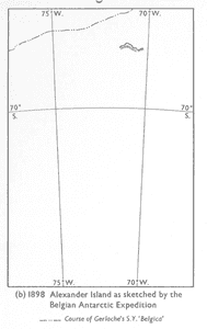
On 16 February 1898 Adrien De Gerlache, a Belgian Naval officer in ‘Belgica’, at 69.8S 70.6W sighted Adelaide Island and Alexander Island, but fast ice prevented approach.
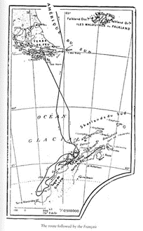
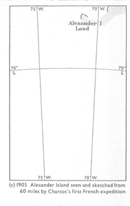
On 15 January 1905 Jean-Baptiste Charcot was appointed leader of the French Antarctic Expedition with the ship Français. South west of Adelaide Island he ran aground within sight of Alexander Island and had to retreat northwards sighting the coast of Loubet Land to the east. Charcot was divorced for desertion by his first wife Jeanne, a grand-daughter of Victor Hugo.
In 1907, Charcot married Marguerite “Meg” Cléry. She was a painter and illustrator who accompanied him on some of his voyages and showed him constant support. At the end of the year their daughter, Monique was born.
Continuing from Home Page….
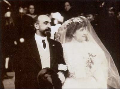
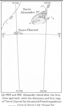
15 January 1909 Charcot, in Pourquoi-Pas ? rounded the southern cape of Adelaide Island and named it Cape Alexandra after the royal spouse of Edward VII. This was in honour of the English Captain Biscoe who had discovered the island.
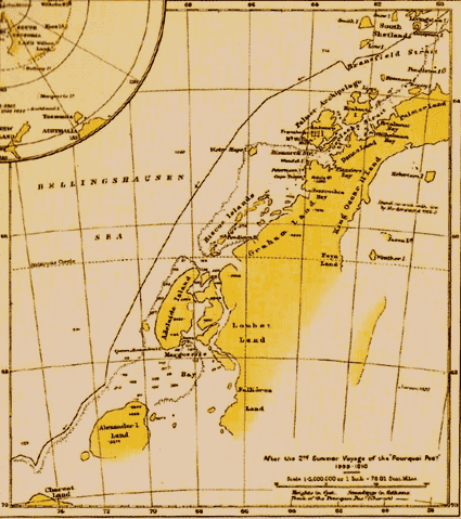
Charcot also named the bay, Marguerite, after his wife and Jenny Island after the wife of second officer Bongrain. A sledge journey north in Laubeuf Fjord indicated that Adelaide Island was indeed separate from the mainland. Charcot approached within 3 miles of Alexander Island and added detail to the chart but was hampered by ice and weather. Unable to find a place to winter he headed north.
Charcot returned south in 1910 but was prevented by ice from entering Marguerite Bay. Following the ice SW he discovered Charcot Land which he named after his father.
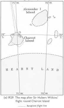
28 November 1928 saw the first airplane flight in Antarctica from Deception Island by the Wilkins expedition. A flight down the East Coast of the Antarctic Peninsula gave the mistaken impression of a series of islands separated by ice filled straights. Charcot Land was shown to be an island.
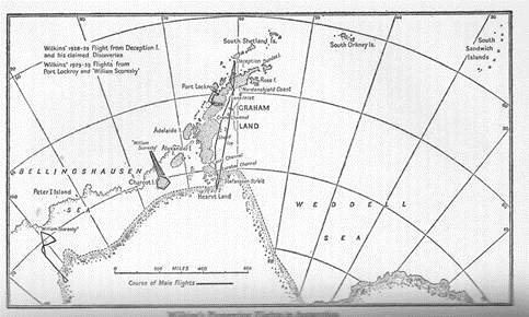
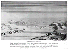
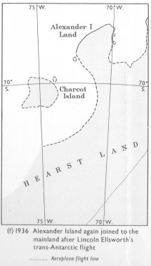
23 November 1935 Ellsworth made the first powered flight across Antarctica from Dundee Island and appears to confirm Wilkins mistaken impressions. Discovers the Eternity Range.
A 1937 re-interpretation of the Ellsworth photographs by Joerg, stimulated by preliminary BGLE reports, showed a conjectured fault depression separating Alexander Island from the mainland.
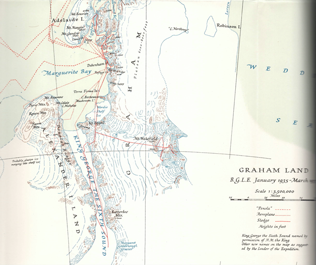
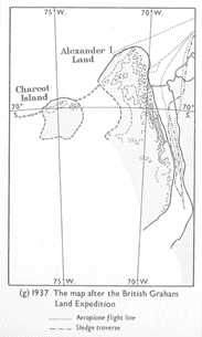
The British Graham Land Expedition (BGLE) planned to establish a base in Marguerite Bay and to sledge through Stefanson Strait to explore the Weddel Sea coast with a second party exploring south of Alexander Island.
24 February 1936 Rymill on Penola entered Marguerite Bay and anchored in the Leonie Islands. After air reconnaissance they selected a base site at the Debenham Islands. Flights showed the country was very different from the existing information on the chart and they had to modify their plans accordingly.
For the first time Marguerite Bay begins to take on a recognisable form. Exploratory surveys were carried out by sledge wheel and compass traverses between star or sun-fix positions. A wireless set allowed the surveyors to receive accurate time signals from Washington or Buenos Aires. Plane-table equipment was used to carry out the detail mapping together with panoramic sketches and theodolite angles.
Mt Wakefield was found to be coincident with Ellsworth’s Eternity Range which BGLE were not aware of, so Ellsworth’s names had priority.
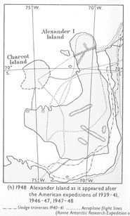
5 March 1940 Byrd, in Bear and North Star, as part of the US Antarctic Service Expedition (USASE) entered Marguerite Bay and established East Base on Stonington Island. Sledge journeys were made to the SW reaching Eklund Island proving in the insularity of Alexander Island. Then south down the East Coast of the Peninsula to 72S. Flights disproved the existence of any of the straits seen by Wilkins and Ellsworth and showed that the Peninsula was part of mainland Antarctica.
The probability of US involvement in the 1939-45 war forced the expedition to be curtailed in 1941, ships could not approach because of heavy sea ice and the personnel were evacuated from base by air to the Mikkelsen Islands where the Bear was anchored.(now renamed Watkins Island in the Biscoe group). The impending war saw the majority of the personnel called up for military service and only a limited number of their results have been published.
Richard B Black was in command of East Base, he named features after his father George Black and his wife Aviza Johnson Black.
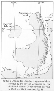
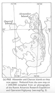
In the 1960s Derek Searle produced an excellent evolution of the map of Alexander Island published by the Geographical Journal in June 1963 which gave several pointers for this article.
References:
F. Debenham (Editor) The Voyage of Captain Bellingshausen to the Antarctic Seas 1819 – 21
R. K. Headland A Chronology of Antarctic Exploration
Adrien de Gerlache Voyage of the Belgica
J. B. Charcot Towards the South Pole aboard the Francais
J. B. Charcot Voyage of the “Why Not ?”
John Grierson Sir Hubert Wilkins – Enigma of Exploration
Lincoln Ellsworth Beyond Horizons
John Rymill Southern Lights
Proceedings American Philosophical Society Vol 89 No. 1 April 1945 – Reports on the Scientific Results of the United States Antarctic Service Expedition 1939-41
J. S. Pedersen and P. Curtis – The Mapping of Antarctica
D. J. H. Searle The evolution of the map of Alexander and Charcot Islands, Antarctica – The Geographical Journal Vol 129, Part 2 June 1963
And of course frequent searches on Wikipedia etc.
Richard Barrett – February 2021
Topographic Survey and Mapping of the Marguerite Bay Area after 1944 – Richard Barrett, Tim Christie, Roger Scott, John Yates
Extracted from “Topographic Survey and Mapping of BAT” by Barbara McHugo by Richard Barrett
This page tells the story of the establishment of Topographical Survey Control in the Marguerite Bay area, carried out from Detaille Island Base (North of Marguerite Bay), Horseshoe Island and Stonington Island in the Fjords, to Fossil Bluff in the South, continuing on from the work done further North including from Hope Bay, Port Lockroy and Prospect Point; and culminating in the use of the BAS Twin Otters for survey work in some difficult areas.
Other than the maps, this is not intended to be a detailed record of how each station was established and surveyed in, but instead, a place to perhaps capture the many moments when things suddenly came together, or more likely, did not go quite as planned.
More miscellaneous maps are HERE until situated
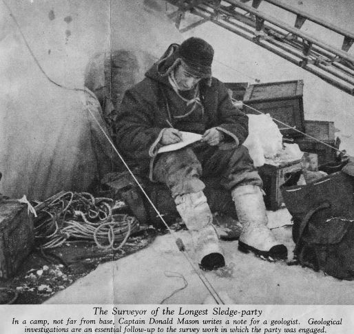
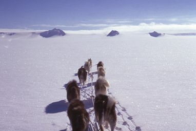
1946-7 – Freeman and Mason at Stonington Island
Established 17 star position line fix at Stonington, mapped the island at 1:2,000 and carried out sledge wheel and compass survey of adjacent mainland coast and peaks. Nov 1946 Doug Mason travelled north on Plateau to 66.5S and concluded Plateau weather and topography was unsuitable for triangulation and air photo control. March 1947 a route over the plateau to the Larsen Ice Shelf was proved and mapped at 1:250,000
From a baseline on the sea-ice, Reg Freeman observed and beaconed a triangulation scheme for a local map at 1:20,000 scale, including soundings through the sea-ice.
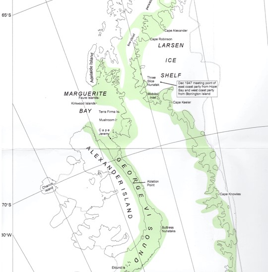
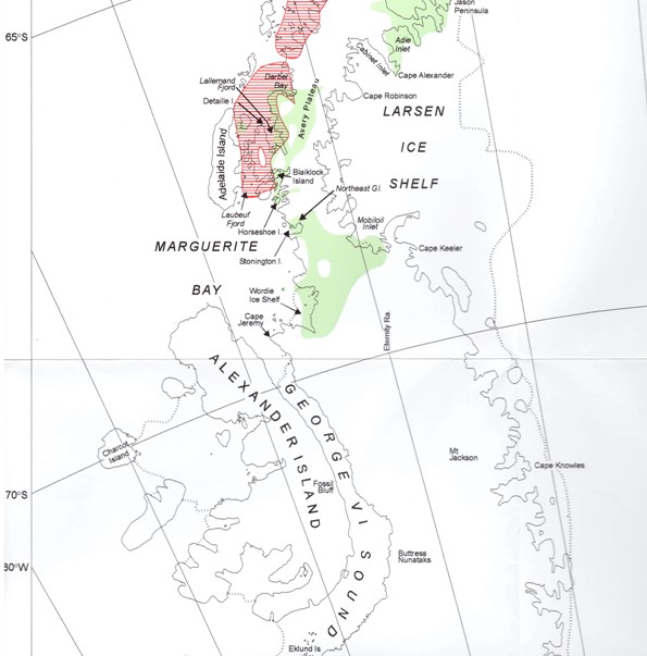
Green areas covered by Exploratory Surveys
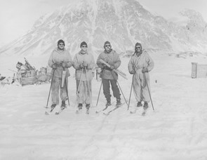
1947-8 – Freeman and Mason at Stonington Island with RARE
In March 1947, the private US Ronne Antarctic Research Expedition under Finn Ronne reoccupied the old USASE buildings at Stonington and after some discussion instigated a RARE/FIDS survey party under Doug Mason.
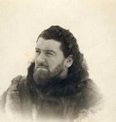
(Photo: Kevin Walton courtesy of Jonathan Walton)
The 4 man party supported by RARE planes sledged down the east coast from 68S to nearly 75S where the Bowman Peninsula meets the edge of the Ronne Ice Shelf, travelling 1930km in 105 days. Exploratory surveying by sledge wheel and compass with sun azimuths at camp sites and minor details fixed by compass bearings. Aneroid heights were supplemented by sea level reading in rifts in the ice shelf. Panoramic photographs were taken at survey stations which proved invaluable when plotting the maps back in the UK. Features on the existing maps were found to be up to 80km in error.
Dec 1947 Reg Freeman led a party to Three Slice Nunatak to meet the Francis party, sledging and surveying south from Hope Bay, and led them back to Stonington.
(The RARE aerial photography was not made available to BAS until 1957.)
1948-9 – Brown and Blaiklock at Stonington Island
Colin Brown exploratory surveying the coast south from base to Cape Jeremy, positioned the islands in southern Marguerite Bay and the NE coast of Alexander Island, and subsequently down the King George VI Sound to Ablation Point to link up with BGLE surveys.
The powers that be allowed some amateur surveyors, geologists Fuchs and Adie, to survey the southern coast of Alexander Island and in the area of Buttress Nunataks on their journey to Ekland Island.
Ken Blaiklock surveyed the islands in northern Marguerite Bay and the east coast of Adelaide Island as far as The Gullet where there was open water and discovered the Emperor penguin rookery on the Dion Islands. He surveyed the fjord area running closed traverses around the major islands.
In mid-winter 1949 Blaiklock visited the Faure Islands and carried out an astro-fix but the sight of open water brought a hasty conclusion to the work.
Between major journeys the surveyors continued the local triangulation started by Reg Freeman.
1949-50 – Brown and Blaiklock at Stonington Island
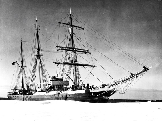
The good sea ice which had allowed the surveyors to complete historic journeys displayed on the maps for a generation of Marguerite Bay Fids, now failed to go out and allow the relief. The Stonington Fids became “The Lost Eleven” of news headlines. The decision was taken to close Stonington and the RRS John Biscoe arrived and closed the base in Feb 1950.
Green areas covered by Exploratory Surveys
Red-line shading areas covered by Systematic Triangulation
1955 – FIDASE (The Falkland Islands and Dependencies Aerial Survey Expedition 1955 – 57– Richard Barrett
In July 1945 Peter Mott, who had spent the war years with the Indian Military Survey, wrote to Brian Roberts (formerly of BGLE) at the Foreign Office Research Department with a proposal for an air survey of the Antarctic Peninsula. Wheels turned very slowly and Peter was recruited into the Colonial Survey department of Brigadier Hotine, but instead of developing the Antarctic project he was instructed to go to Ghana. Declining this offer Peter joined Hunting Aerosurveys Ltd as Chief Surveyor.
1955-56 – Searle at Horseshoe Island
A new base was established at Horseshoe Island in March 1955 but poor sea ice in 1955 and 1956 curtailed activities. Derek Searle produced a 1:25,000 detailed map of the island for the geological work. He recced a route up on to the plateau and another northwards. From a sun-fix at base and a baseline measured on the sea ice, a small triangulation scheme was beaconed and observed on the NW of the island and extended eastwards.
A new field hut was erected on Blaiklock Island for further work.
1956-57 – Murphy and Orford at Detaille Island
A new base was established at Detaille Island in February 1956. Before the sea ice formed a small triangulation scheme on the island was beaconed and observed and a detail map of the island performed at 1:2,400 scale. Sledge wheel and compass surveys where carried out along the mainland coast and eventualyl up onto the Avery Plateau at 1680m where they were able to link to work from Mason’s 1946 plateau survey and obtain a sun-fix.
1957-58 – Erskine and Madell at Detaille Island
Sledge wheel and compass surveys of glaciers into Darbel Bay and Lallemand Fjord and onto Avery Plateau, better weather allowed some star fixes to be observed. FIDASE photography became available and the survey work changed to systematic triangulation to provide control points for mapping. Angus Erskine and Jim Madell measured a baseline near base and reconnoitered a triangulation scheme from 66.5s along the coast and down Lallemand Fjord which was observed in the spring. When the sea ice was unsafe further work was done on the local map for the geologist and a 16 star astrofix observed.
1957-58 – Gibbs and Rothera at Horseshoe Island
Based at the Blaiklock Refuge Peter Gibbs and John Rothera worked north into the Arrowsmith Peninsula between them and Detaille Island and west to Laubeuf Fjord with chains of triangulation and a 20 star astro-fix at Blaiklock.
1958-59 – Foote and Rothera at Detaille Island
John Rothera extended the triangulation into northern Adelaide Island and south to the work in Laubeuf Fjord and down the Lallemand Fjord to connect with the work in the Arrowsmith Peninsula. Brian Foote extended the work northwards into Darbell Bay.
Further detailed survey work was done for the geologists and in March 1959 the base was closed. Unusually the winter sea ice had not gone out and the Fids had to sledge 48km across the sea ice to reach the RRS John Biscoe.
1958-59 – Gibbs and Forster at Stonington Island
The Stonington base was reopened in March 1958 but no sea ice meant the work was confined to mainland areas accessible from base. Sledge wheel and compass surveys fixed by sun-fixes every 50-60km enable the pair to survey the area between the base south to the Wordie Ice Shelf and across the plateau to Mobiloil Inlet.
In March 1959 severe ice conditions prevented the relief of the base and it was again closed. Fids sledged north to Horseshoe Island where they were picked up by US Navy helicopters.
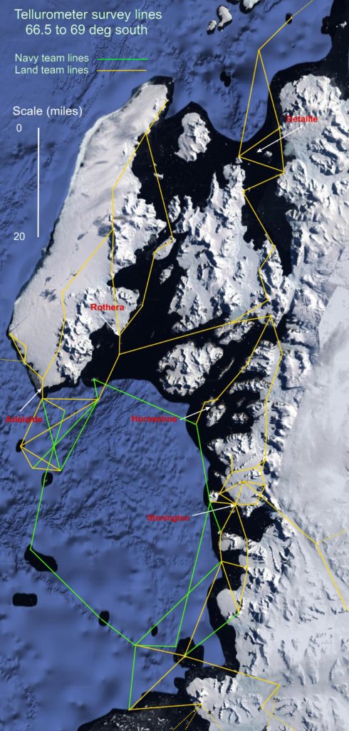
In January 1959 the first Tellurometers were introduced into the Antarctic at Deception Island, supported by HMS Protector and its helicopters. The MRA1 instruments weighed 60kg and took an hour to warm up and measured the transit time of the measurement. From 1961-71 the MRA2 instruments were fitted with stormproof muffs and an oven and only took only 5-10 minutes to warm up. From 1973 the MRA3 instruments were used which gave a readout of distance in metres.
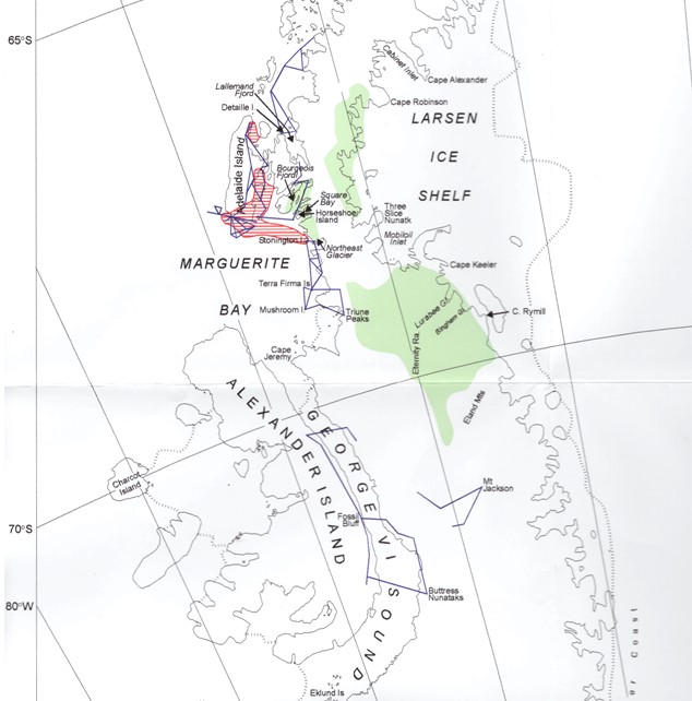
Green areas covered by Exploratory Surveys Red-line shading areas covered by Systematic Triangulation
Blue Lines – Tellurometer Traversing
1960-61 – Forster at Stonington Island and Horseshoe Island
Heavy sea ice prevented access to Stonington but in Feb 1960 a party of 4 was flown into Horseshoe Island. Peter Forster mapped areas of Bourgeois Fjord and Square Bay not covered by air photography. The party then moved south to Stonington. Exploratory surveys were carried out between 68.5s and 69.5s the survey linked to work by BGLE 1936 and down the Lurabee Glacier to work by Mason 1947
1961-62 – Chapman and Metcalfe at Stonington Island
In Aug 61 Howard Chapman and Bob Metcalfe set of from Stonington in two Muskeg tractors to travel across the sea ice and south down King George VI Sound to Fossil Bluff. One Muskeg was lost at sea and with the aid of dogs 5 traverse stations were recced south of Fossil Bluff but meltwater on the Sound stopped work in January and the surveyors were withdrawn by air. In March 62 Metcalfe flew back to Fossil Bluff to observe a 16 star astro-fix.
1962-63 – Preston and Wright at Adelaide Island
In Feb 1961 a new base was established on the SW point of Adelaide Island. Frank Preston and Alan Wright began a Systematic Triangulation survey to connect and extend the work of the surveyors from Detaille and Horseshoe. An astro-fix was observed during the winter and local mapping to assist the geologists.
1962-63 – Metcalfe and Morgan at Stonington Island
In August 1962 Bob Metcalfe and Howard Morgan mapped the area between North East Glacier and Square Bay.
In October Metcalfe and Morgan were flown south to Fossil Bluff, travelling by muskeg and dog sledge and with air support 13 new stations were established and 15 lines measured extending from Fossil Bluff to Buttress Nunataks.
1962-63 – Nash and Wright at Adelaide Island
The arrival of Tellurometers and the RRS John Biscoe to carry out hydrographic survey, enabled nine lines to be measured to offshore island stations. The triangulation programme was changed to a traversing scheme around the flanks of the mountains of Adelaide Island.
Based initially on RRS John Biscoe and later on HMS Protector, Dave Nash, Alan Wright, Ivor Morgan, Bob Metcalfe and Ken Blaiklock traversed west to Amiot Islands and south to Faure Islands, and later the ships provided logistic support for the final observations in the north of Adelaide Island.
1963 – McMorrin GA at Stonington Island
Ken Blaiklock was scheduled to lead an air-supported survey to the Cabinet Inlet on the East Coast but the project was abandoned after 13 weeks of bad weather. Ian McMorrin accompanied a geology/geophysics party on the East Coast between 68S and 66.5S doing exploratory survey work connecting to work by Francis and Mason in 1947
1963-64 – Nash and Morgan at Adelaide Island
No air support was available this season and the surveyors sledged to Fossil Bluff. From Fossil Bluff Ivor Morgan and Dave Nash sledged and recced north setting 3 stations on the east side of the Sound. A route onto the plateau at 71.5s was recced and 2 stations for a trans plateau traverse were established.
1964-65 – Armstrong and Rider at Adelaide Island
With air support Armstrong and Tony Rider measured eight Tellurometer lines in a traverse running east to Mount Jackson with the final station at 2740m. Two sun-fixes helped to roughly position this isolated piece of work.
(How this piece of survey work came to be prioritised might be the result of having a famous climber as BC and Mount Jackson at 3184m thought to be the highest peak in the Antarctic Peninsula. In 2017 it was demoted into second place below Mt Hope at 3,239m. John Cunningham led a first ascent of Mount Jackson in Nov 1964, and Mt Hope was first climbed by Keith Holmes and Mike Cousins on Christmas Day 1965. This also highlights the less than perfect heighting used on some of the early surveys)
The primary task was Tellurometer traversing to link the earlier triangulation schemes from Detaille and Horseshoe, this was recced in the winter of 65 but work was held up when sea ice problems marooned the party on Detaille Island.
Cousin made a “sketch” survey of the Bingham Glacier on a geological trip, heights obtained using an erratic aneroid barometer.
1966-67 – Marsden and Boulding at Stonington Island
Between Oct 66 and Jan 67 when neither aircraft or Tellurometers were available Neil Marsden and Dick Boulding carried out exploratory surveys in the Bingham Glacier and south to 71s. Details were mapped by plane table either side of the Eternity Range and south to the Eland Mountains.
While the surveyors were in the field the US Navy began flying Trimetrogon photography eventually covering 22,000 sq. miles of BAT which was to be a game changer in how BAT would be mapped and the topo surveying required.
1967-68 – Boulding and Postlethwaite at Stonington Island
Dick Boulding and Derek Postlethwaite were flown to Fossil Bluff in Oct 67 and with dog teams and two Muskegs worked north to 70.2s and a Tellurometer traverse measured up the west side and across the Sound. The 1963 stations on the east side were checked but could not be measured because of flooding.
1968-69 – Postlethwaite, Wainwright and Fielding at Stonington Island
In March 1968 RRS John Biscoe transported three parties and dog teams to Blaiklock Island to continue the work began by Tony Rider in 1965. They set up 4 stations and measured 3 lines getting back to base in July.
Mike Fielding and Derek Postlethwaite worked from the sea ice to extend Tellurometer trilateration to the Terra Firma Islands latterly assisted by RN helicopters.
Phil Wainwright used hand held helicopter photography and pre-marked control to compile large scale maps of several of the islands for the geologists.
In 1969 American engineers began to establish survey control east of 65W and between 73S and 75S for geological mapping of the Lassiter Coast.
1969-70 – Fielding and Bentley at Stonington Island
In July 69 with good sea ice Paul Bentley and Mike Fielding sledged to Horseshoe Island and measured a Tellurometer traverse from their previous work to connect with Searle’s work at Horseshoe in 1956 and Marguerite Bay work.
Bentley and Fielding ran a closed Tellurometer traverse to the Mushroom Islands and southeast across the Wordie Ice Shelf to Triune Peaks. An inconveniently positioned ice berg prevented the measurement of one line and the break up of the sea ice saw the surveyors depot the survey equipment in the islands and beat a hasty retreat to the coast.
(see Steve Wormald’s tale below of recovering the gear, Stonington 1970)
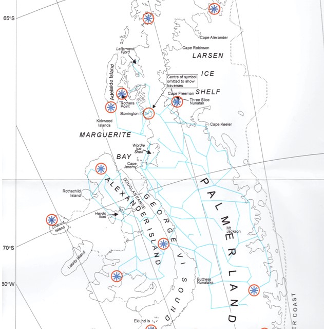
Blue Lines – Tellurometer Traversing
Blue stars inked circles – USGS Doppler satellite fixes
Stonington Island continued as the main base for survey activities supported by dog sledging until it was closed in 1975, at which point Rothera became the base for all air operations and mechanised transport.
During the early 1970s poor sea ice was the norm and HMS Endurance surveyors ran a western Tellurometer traverse south from Adelaide via Kirkwood Islands to connect to existing work from Stonington.
From base in Autumn and Spring despite the usual bad weather, low temperatures and strong winds, surveyors, Tim Christie, Paul Bentley, Paul Gurling, John Yates and Roger Scott, recced and observed a Tellurometer traverse running inland from Stonington and northwards along the Antarctic Peninsula to link direct to the Detaille Island Lallemand Fjord surveys. HMS Endurance surveyors with helicopter support were able to link from high level BAS stations in the fjords and some of the inland traverse stations to their Marguerite Bay work.
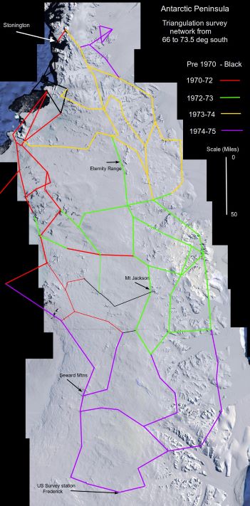
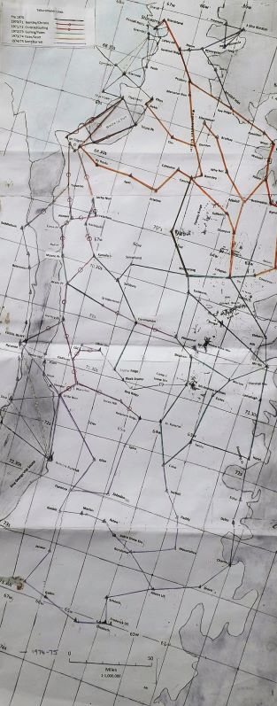
1970-75 – Exploration from Marguerite Bay to 73S – Richard Barrett, Tim Christie, Roger Scott, John Yates
The summers of 1970-75 were periods of extensive survey activity. Field parties travelling mainly by dog sledge and closely supported for short periods by the aircraft, journeyed south from Stonington to complete the establishment of a survey framework in George VI Sound and right across the Antarctic Peninsula on the Graham Land and Palmer Land Plateaux south of 68.5S and linking to work done by the American engineers on the Lassiter Coast. Each season field parties stayed in the field for six months, travelled up to 2000km and measured some 30 – 40 traverse legs. In 1970, BAS obtained prints of the US tricamera air photography of the area. During the winter the surveyors prepared uncontrolled sketch maps of their working areas and these proved invaluable to all field workers, especially for detailed control planning and for navigation; they were later amended from ground photographs and from new field data. By 1973, images of the Antarctic recorded by the orbiting ERTS satellite at a scale of 1:3m became available for the first time and these too were invaluable. The origin of the whole survey network south of 68S was the astro fix at Stonington and as the most southerly work was some 640km away, the opportunity to use satellite position fixing was timely.
Terra Firma Survey Gear Recovery via Marguerite Bay Sea Ice
In November 1969 the Summer Survey party were threatened with the possibility of being cut off from Stonington by open water, so it was decided to leave the survey gear on the Terra Firma Islands and sledge south to Fossil Bluff. En route it was decided that they should recce the Mt. Edgell area and both sides of the King George VI Sound.
As sea ice had been poor all year it was decided in the winter of 1970 to try and uplift the survey gear and depot it along with as much manfood and dogfood as possible somewhere on Cape Berteaux, from where access could be gained overland from Stonington via the Plateau, using the depot put on the Plateau via Sodabread.
1970-71 – Bentley, Christie at Stonington, Gurling at Fossil Bluff
Paul wintered at Fosill Bluff in order to observe an astro-fix. Paul Bentley, Tim Christie and Paul Gurling made a survey connection betwen Stonington and Fossil Bluff with a 200 mile long closed tellurometer loop which involved three nearly 50 mile long tellurometer lines across the Wordie Ice Shelf, ten lines south from Mt. Edgell on the east side of King George VI Sound, and two lines across the Sound to link up wth the five lines along the western edge of Sound that had been measured in 1967. This traverse effectively connected the survey stations in Marguerite Bay with the Marcello Loop running south down the Sound (from Fossil Bluff to Buttress Nunatak at 71.45S) which had been measured in 1962/63 by Bob Metcalfe and Howard Morgan.
The Cross-Wordie Lines – Tim Christie
The main task was to make a survey connection between Stonington to Fossil Bluff with an unbroken chain of tellurometer lines. Up to that time, although some survey had been done from Fossil Bluff, this was a ‘floating” survey with no connection to the survey network on the rest of the Antarctic Peninsula the surveys from Stonington having only come as far south as the Wordie Ice Shelf at Latitude 69 deg S.
We thought that measuring the first three tellurometer lines across the Wordie Ice Shelf might cause us some problems, partly because of their length, partly because of the logistic difficulty of getting the two survey teams on the opposite side of the ice shelf at the same time and partly because the north and south sides of the Wordie were in different weather systems. What we didn’t expect was the crisis that arose every time we were about to measure the lines.
1971-72 – Christie and Gurling at Stonington
Once the Stonington to Fossil Bluff connection had been made the surveyors were able to measure the five tellurometer lines needed to close the ‘floating’ traverse to Mt. Andrew Jackson which had been measured in 1964/65 and to link it to the Stonington-Fossil Bluff Marcelo tellurometer networks. While one party (Gurling) was lying up in bad weather waiting to measure the final angle on the Mt. Jackson traverse, the other party (Christie) made an exploratory journey on to the top of the Palmer Land Plateau to find potential rock-based survey stations from which trigs on both sides of the Plateau could be seen.
The Coromandel Journey – Tim Christie
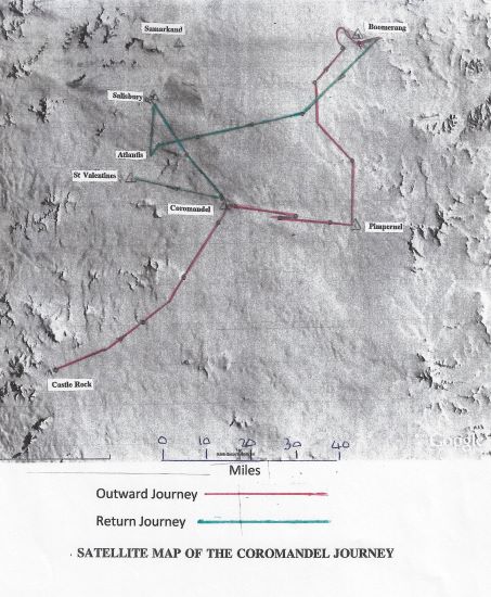
In spite of the fact that I had accidentally dropped my tellurometer over a five hundred foot cliff at Carse Point and that my fellow surveyor, Paul Gurling, had lost all his survey equipment (worth probably at least E30,000 at today’s prices – 2017) when it was blown away by a ferocious katabatic on the Harriet Glacier, by Christmas 1971 we had completed the survey task assigned to us by BAS which was to provide an accurate survey link between Stonington and Fossil Bluff, thus linking Graham Land and Palmer Land.
It involved, amongst many other things, measuring three 50 mile long tellurometer lines across the Wordie Ice Shelf to an accuracy of a few inches and measuring a theodolite angle from Mount Edgell to a cairn which we had built on the summit of Butson Peak, near Stonington, the previous winter, which was 105 miles away!
1972-73 – Gurling and Yates at Stonington
Paul Gurling and John Yates occupied these stations and established a tellurometer network across the Peninsula between 70S and 72S (in a N-S direction), and between the Larsen Ice Shelf and King George VI Sound (in an E-W direction). Several stations on the East Coast that had been established in the 1960’s wereoccupied during this period. Much of the survey work was carried out in conjunction with BAS aircraft, with the surveyors being landed close to station sites in a leapfrog mode. In February 1973, Roger Scott was flown in to the field to replace Paul Gurling.
1973-74 – Yates and Scott at Stonington
John Yates and Roger Scott completed the W-Y-T-E link through to ARCH, more Stonington local survey and the extremely hazardous and difficult GRANDSTAND – SENTINEL link (read that story HERE!).
The summer programme completed the control of the American aerial photography working north from 70 00S to 68 00S right up the Palmerland Plateau and linked back to Stonington. This included 2 cross plateau traverses to EDGELL SPUR and SICKLE either side of the Wordie Ice Shelf. Superb air support and good weather enabled rapid potential station reconnaissance and the establishment and measurement of linked survey control northwards along the east coast peninsulas from Cape Boggs to Mobiloil Inlet. 40 stations were established/visited and 40 tellurometer lines completed 1042 km of survey traverse.
1974-1975 – Scott and Barrett at Stonington
At the end of August 1974 a traverse with aircraft support was run out from the Plateau along the Joerg Peninsula (68 12′ S, 65 11′ W) to Three Slice Nunatak (where Fuchs and Adie’s party traveling south from Hope Bay had met the Stonington party in 1947).
After the Three Slice Nunatak project the survey parties were flown south to Buttress Nunatak at 71 45’S on the east side of King George VI Sound )some 20 miles south of Fossil Bluff to start the major task of establishing a survey framework and mapping across the southerly part of Palmer Land Peninsula between 72S and 73S – an area that no one had travelled before and which appeared to have few nunatuks in the middle of it. A tellurometer traverse was observed down the edge of the Sound and then across the Plateau to incorporate three U.S. stations at about 73S, and with vital aicraft support, a traverse was then observed up the East Coast to be linked to the surveys done in 1972. This work represented the final work based out of Stonington, which was closed in 1975.
1975-76 – Barrett and Shaw from Adelaide
During the 75-76 season Richard Barrett and Colin Shaw extended the survey control into Alexander Island using skidoos and air support based out of Rothera. A USGS party, Wayne Gatson and Bill Schoonmaker, supported by BAS ships and aircraft observed satellite fixes at 28 stations on the Antarctic Peninsula and off lying islands, 13 of those fixes were at existing BAS, USGS or Argentine survey stations.
In the interest of brevity only the surveyors have been named in this summary. All of us acknowledge the enormous assistance, energy, and encouragement generously given by their GAs, BCs, Pilots, Air Mechs, Ship’s Captains and Crew, Radio Ops, Diesel Mechs, Met Men, other Field Scientists, Liz Fleming and Barbara McHugo.
And of course their Dog Teams.
A S T R O F I X E S
Positional star fixes have been observed at Stonington (Stonastro), Adelaide and Fossil Bluff.
The Stonington astrofix was first measured by Freeman in 1946, (ref El/47, 22/47). The observations were repeated in 1966 by Boulding using star transits and 8 position lines for latitude, and 8 position lines for longitude (E110/44). The results of the two observations agree to within one second of latitude and four seconds of longitude. The accepted coordinates for Stonastro are:
- Latitude 68 Deg 11’ 17.00″ S
- Longitude 67 Deg 00′ 38.00″ W
Notes on Accuracy – Richard Barrett
The agreement between two astrofixes of one second of latitude equates to a little over 30m on the ground, however the standard error of the observation to be used in calculation would be between 60m and 100m.
The satellite doppler position fixes observed in 1975/6 achieved a standard error of 50m divided by the square root of the number of satellite passes recorded, 32 passes at Stonastro giving a standard error of 8.8m.
Today (2021) GPS-enabled smartphones are typically accurate to within a 4.9 m radius under open sky.
High-end users boost GPS accuracy with dual-frequency receivers and/or augmentation systems. These can enable real-time positioning within a few cm, and long-term measurements at the mm level.
Rothera Geodetic Points
Rothera site possesses references from two space geodetic techniques;
- Two GNSS stations “ROTH” (part of the IGS network since March 2010) and “BAS”.
- One DORIS station, relocated in 2018, this is a global system which tracks satellites
- Furthermore, Rothera is equipped with :
- A tide gauge
- Relative gravimetry points
- Geodetic points.
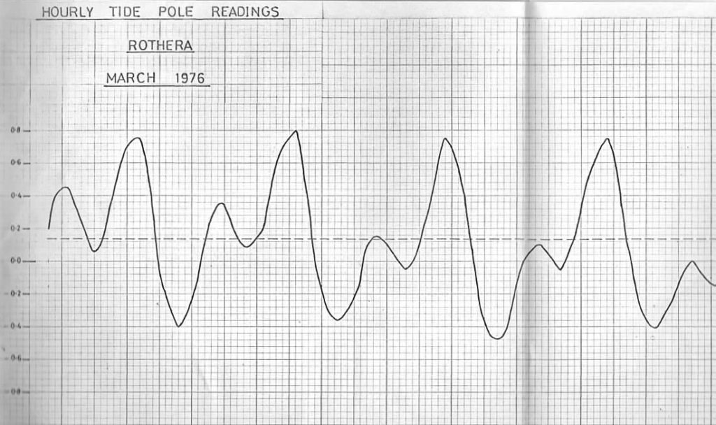
Rothera is now positioned so precisely that you can detect it moving, currently heading East at 14.97 mm per year and North at 9.79 mm per year and rising by 4.40mm per year.
(To think I took tide pole readings every hour for five and a half days to establish a benchmark, it will be 198mm out by now. )
Richard Barrett – 2021
A Topographical Data Set of the Glacier Region at San Martin – Richard Barrett
Richard also added this for those with a technical interest in Marguerite Bay Surveys.
I had a look to see if any topo survey was done out of San Martín and found this interesting (well it will be interesting to enthusiasts) German paper from 2000 on how photogrammetry had moved on.To think that in 1975/6 we were the first surveyors to have electronic calculators into the field!
Interesting 3D visualisation of Roman IV.
I noted how the Northeast glacier has retreated from Stonington Island but not from Fitzroy Point, which I imagine is the result of spanning the dogs up there (Click Image to open)