Winter Work at Horse Point – Our Most Challenging Project
Within the first few days of the sun’s return we would set out for our first field work of the new season, in August 1975. Our first trip each year would be to Horse Point.
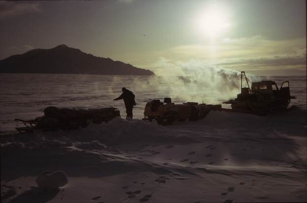
Photo 1: Getting ready to set off for Horse Point
Sun is getting higher in the sky. Temperature -40degC
Horse Point is located opposite to Fossil Bluff on the eastern side of George VI Sound, about 25km from the Bluff.
Whilst it is just across George VI Sound from our Base, it is totally different in physical character. The rounded mudstone mountains of Alexander Island to the rear of Fossil Bluff make way for great bastions of igneous rocks at Horse Point, this being the western edge of Graham Land (Antarctic Peninsula) and completely separate, geologically, from Alexander Island.
We arrived at the foot of Horse Point on a gloomy and raw late afternoon on August 13th, 1975.
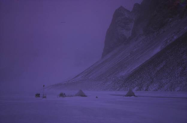
Photo 2: Camp on the Lake at Horse Point
We established our living tent and a work tent to house the Tide Gauge (recorder). The camp is situated on the ice surface of the lake, about 20metres from the tide crack which then leads to fast ice to the base of the mountain. A quick temperature measurement on the thermometer was done just before turning in. It read just below -40decC. This period, at the transition from winter to early Spring, is the coldest part of the year. Indeed, more was to come…
There was plenty of work to do at Horse Point and this included: –
- Tidal Measurements
- Topography of the Lake area (Pony Lake)
- Bathymetry of the Lake
- Oceanographic measurements and
- Mass balance Ice Studies.
The following morning, we established the tide gauge, paper recorder etc. The tide gauge was set up on the lake ice and a hole drilled through the ice and wire and weight passed through this. The weight rested on the lake bottom. The lake was linked to the Sound (ice sheet) and, as the sea under the Sound raised and dropped with the tides, the lake ice surface elevation reacted accordingly. The tide gauge would record the ice surface vertical movement (i.e. the effect of the tide) as the lake ice surface raised and lowered. It worked fairly consistently in a heated work tent.
Occasionally the drilled hole /wire arrangement would ice up, so although automatic recording was taking place, a regular checking up was needed. A lunar cycle of the tidal movement would be recorded and traced out.
On our second evening, the temperature dropped to -45degC. Just after scradge was done, Jonathan and I both developed the grandfather of all headaches, and with it, sky-high pulse rates. It was necessary to open up the tent tunnel entrance and gulp in fresh air (i.e. super fresh at -45degC!) until things in the head calmed down a bit. (Gulping in the air was almost enough to loosen any tooth fillings through differential contraction!) Checking my pulse, whilst hanging out of the tent tunnel entrance, gulping in the air, the pulse recorded 225bpm.
Neither the Primus nor Tilly lamp were burning with dirty flames, and the tent vent was clear. It remained a bit of a mystery what caused the problem, but we put it down our symptoms to carbon monoxide poisoning, though neither us developed light-ish pink lips. We changed out the Primus, Tilly and fuel and that fixed, but not solved the issue. The lurky headaches, though less intense, lasting for several more days.
Winter Camping
That night was the first occasion for many months for jumping into two sleeping bags. These bags were “Fairy Down” from New Zealand. The sleeping bags were tucked together as one. Normally, I would sleep in one with the other underneath me. That way, if temperatures dropped during the night one could wriggle into the bottom bag without too much effort and effectively kiss goodbye to the cold, till morning. These Fairy Down sleeping bags were excellent.
Winter camping is very different than in the other seasons. For most of the year very little frost forms overnight on the inside of the inner tent and this can be melted off quickly with the Tilly and Primus running. In winter camping the frost forms all the way from top to bottom of the inner tent. Running the Tilley and Primus together melt away this inner tent frost in half an hour or so, but at this camp, even an hour of Tilly and Primus roaring away could not drive the frost away from below 18’’ to 2ft up from the ground.
In these conditions, for the Inside Man, the early morning start is quite tricky. He has to squeeze out two half arms from the narrowed opening top of his sleeping bag to reach for the meths to fill up the pre-Primus warming cup and light this. Most of the season one match would do the job but in -40deg+ it takes two or three matches and maybe a couple fills of meths to warm up the primus burner tube sufficiently to vapourise the paraffin. It is essential that the Primus flame burns with a clean, blue flame. It was an absolute NO NO to prime the Primus insufficiently (and it not vapourise the paraffin) and a yellow flame and a smoky black flame results on priming. Very messy and dangerous, too.
Timing this start-up correctly and then sliding the two half arms back down into the sleeping bag had to be done with great care to avoid touching the side of the ten. Otherwise, chandeliers of ice at -40+deg C and the lining of frost dust having formed through the night would shower down. Getting some of that into the top of the sleeping bag and down one’s neck would be a hell-of-a start for the day.
Having got the Primus going, normally one would then carefully pull back one’s two half arms and retreat into the depths of the sleeping bag whilst Primus and Tilley roared away to de-frost and take the edge off the space a little. Mostly all this is done by touch in the darkness of early morning.
Tidal Measurements
The next day, after our usual careful and methodical start we continued monitoring the tide gauge, changing the paper rolls, etc. and sorted things out around camp. Jonathan moved our thermometer around to the back of the tent, away from any effect of the sun. Before turning in, on checking the thermometer, it proved difficult to read the temperature, until we realised that the mercury column had given up and retreated wholesale back into the bulb. That made the temperature reading lower than -50degC.
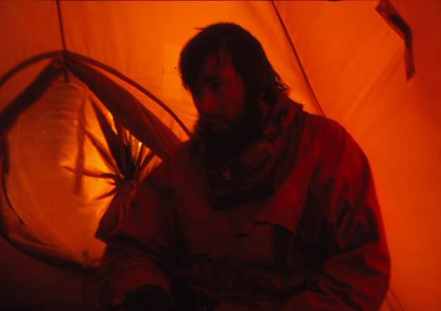
Photo 3: “That minus 50deg feeling…” Jonathan Walton just back into the tent
A Bit of Bathymetry…
The next day we wandered over to the ice pressure ridges where the Horse Glacier merged with the ice shelf. The two (somewhat opposing forces) on meeting create for some interesting ice pressure ridges.
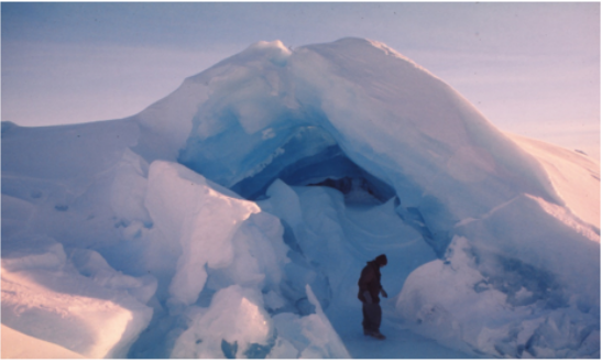
Photo 4: Two opposing ice streams fight it out
In this area, by a great stroke of luck I put my foot through some porridge-ey ice and down into cold water. We couldn’t believe our luck. This was just what we had hoped to find as it gave us access to the sea under the ice shelf.
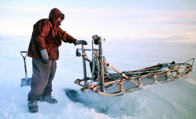
Photo 5: The spot where I put my foot through the ice
Water depth was later measured at 375metres!
We hot footed (or was it wet footed) back to the camp and picked up the fancy Oceanographic Rig that Dr Charles Swithinbank had sent down to us in the previous summer relief.
This winch gear was set up in the “pup tent” and run down under the ice for water samples and for measuring the water depth. After a couple of miss-runs we got the hang of it and took a temperature profile down to 375m. This was the first time for recording of this data under the shelf. We recoded a water temperature to -1.75degC. (And like any self- respecting fjord, we recorded over 500m water depth barely one km. from land.)
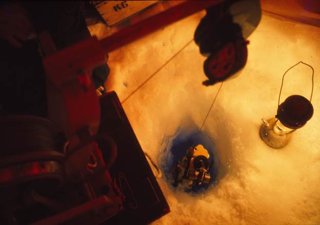
Photo 6: Lowering down our oceanographic sampling unit into the depths
Camp
All the days so far, on this trip had averaged out at -40degC. In the evenings, whilst lying on our sleeping bags in the tent we would hear loud cracking noises, like gun shots, as the surface ice on Pony Lake contracted. On this evening we heard a tremendous crack seemingly right under our tent. Everything shuddered and shook and our drying mukluk boots, which were pinned up in the tent roof, started swaying around!
Jon and I were up in a flash, expecting to see water coming into the tent. The sleeping bags, sheepskin mat, lilo – where all pushed to the side and then the butyl groundsheet lifted – there to see the water bubbling up through the crack… But, hang on a second, the mind under stress can be guilty of imagining things. And so…there was actually no water bubbling up – just a hairline crack in the ice which ran through the whole length of the tent. Panic over.
Weather Change
We continued with tide gauge monitoring and bathymetry over the next few days, as the wind picked up and temperatures lifted. On the 24th August the wind speed was up to 30 then 40 knots. Overnight the temperature rose to -2degC. What a contrast! Next morning wind speed upped to around 60knots with big and violent gusts following through. A few boxes were blown off the tent valance and contents scattered. After retrieving and clearing up we put extra weight on the valence of the tent and parked the skidoo in front of the tent to help as a windbreak, and tied the Nansen sledge to the Keg. (We were camped on hard ice, not snow).
Glaciology.
At the top of the Horse Glacier the snowfields broaden, heading up into the vast icefield of the Antarctic Peninsula. All along the west side of the Peninsula the ice slowly flows down as glaciers to merge into the George VI ice shelf, over time. Some of these glaciers are huge and highly crevassed glaciers (such as the Bertram and Ryder glaciers), but there are some others which are narrow and flow between easily accessible mountains (or Nunataks ). The Horse Glacier is one of these glaciers.
Small vertical height changes of the surface of the vast icefield over Graham Land can be accurately measured and monitored where there is glacier which flows through a narrow passage between mountains, with the benefit of a leverage effect on the ice surface elevation. Such is the situation at the head of the Horse Glacier where we could establish permanent benchmarks (height datums) on the adjacent mountain sides. From here we could establish a profile of the ice surface in position and surface elevation across the head of the Horse Glacier, using our surveying instruments.
Such established profiles can be re-measured 5, 10, 30 or more years later and provide a new surface height profile, and show increase (or decrease) of elevation.
This simple method can give an accurate determination (relative to the earlier established fixed benchmarks) of any change in height of the glacier surface. Thus, an extrapolation over a specific area/ region can allow an assessment of Mass Balance, whether the ice elevation is increasing or decreasing (ablation). A measure, data point, which could possibly point to climate change effect.
Project Work Completed
A couple of weeks later our surveying work, tide gauge measurements and glaciology were completed. It was time to head back to Fossil Bluff, and prepare for our next Project. However, not before a wander around some of the beautiful local scenery by Horse Point.
This following photo shows our Horse Point camp. The camp can be spotted way below on the lake ice (pyramid tent and separate tide gauge tent). Adjacent to the camp is the tide crack and on the other side of tide crack is the fast ice, which has been highly polished, after the recent blow.
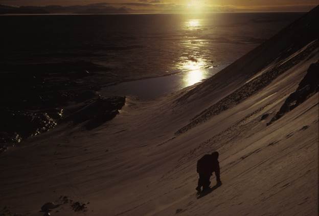
Photo 7: Camp at Horse Point August 1975
All photos by the Author F G Tourney Fossil Bluff 1973 – 1976