The Last Great Dog Journey from Stonington (and a Historic Meeting with Mechanical Dogs) – Chris Edwards
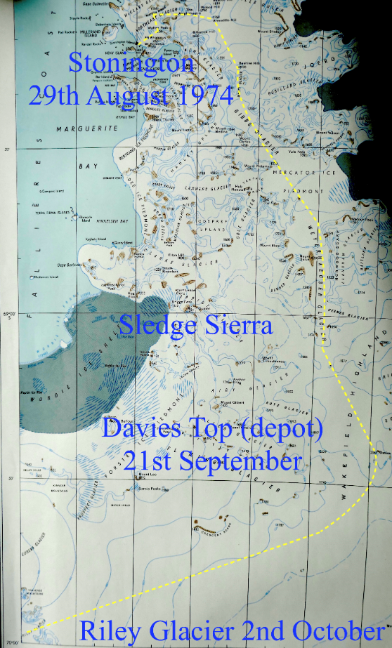
The story really begins at Stonington at the start of the 1974-5 season with the departure of 8 sledges on the 29th August 1974 of the field parties of surveyors, geologists and geophysicists. It also marked the beginning of the end for Base E and also for dog sledging in Antarctica. My diary entry for the 28th reads “…:lunch then Doom! Had to put down 8 dogs – Rona, Nog, Zonda, Dianne, Belle, Rocky, Gareth and Castro.
However, things went smoothly and the whole nasty affair was over by smoko….. Not a good day – feeling very sad”.Many of these dogs I had had in my team and, as the doggy man, knew them all intimately. They were “surplus to requirements” in the overall scheme and it was a shameful, brutal thing to have to do.
At 0940 on the 29th, after a last poignant look around, I made my way to the dog spans and, with the other seven teams departing ahead of me, left Stonington, my home for the previous two years, for ever.
Continued from Stonington page….
Over the next few days man and dog pushed, shoved and pulled tons of food, fuel and equipment up Sodabread onto the plateau. By 2nd September everyone was on the plateau and we headed for Armadillo and thence to Beehive and down the Wyatt Glacier towards the Gibbs Glacier achieving 19 miles that day. A couple of days lie-up because of poor weather was followed by a run down the Gibbs Glacier to Ptolomy depot. The conditions were variable with soft snow making the going quite slow for the lead team to the extent that I had most of the load on my second sledge. At Ptolomy there was a general splitting of the various disciplines with everyone destined for different parts of the Peninsula.

Leaving Ptolomy depot with Chris Knott, (G.A with The Admirals and me with The Ladies), we headed for Mercator Nunatak in “soft deepish snow” The temperature was around -27C and I had to chip the frozen harness off Isolde my lead dog with a hammer!
The 10th September was another day of “evil deep soft” for around three miles as we headed towards Norwood Scarp at the northern end of the huge Weyerhauser Glacier, but that was only the beginning of a long slog towards our next food depot at Davies Top. The conditions on the 11th were even worse with Chris Knott as second sledge some 38 minutes behind after only 3 miles travelled. After dumping my load I went back down the track and helped relay some of the gear and we camped having done only 5.5 miles in total during the day and that includes running up and down the same track. Both men and dogs were cold (-25C) and tired. The following day it was snowing and no visibility and the following day was only marginally better when we only managed about 4 hours of travelling before conditions became unworkable again. All this time we were relying on compass navigation with only occasional glimpses of the scenery around us. The 14th September was another poor visibility day but we managed to reach a point just before a crevasse belt off the Hermes Glacier. We climbed up the last major step in the Weyerhauser Glacier on the afternoon of the 15th and finally onto reasonably good surfaces despite it being manky and drifting snow. The 16th-18th September was spent lying in a tent for most of the day listening to the wind howling up to 40-50 knots by which time we started to shorten rations for both men and dogs given that we still had a way to go to the depot, and not helped by both the Primus and Vapalux lantern refusing to behave , perhaps because of dirty fuel. By late afternoon on the 21st September after starting off in -34C (the coldest I experienced in my 2.5 years south), and passing Damien survey station in low cloud, a run of 10.5 miles brought us to the depot at Davies Top. From there it was effectively downhill to sea level on King George VI Sound. But that was a few miles away across the “bondu” and the head of the Riley Glacier.
On the 24th September plodding across the plateau the weather cleared and we could see something of our surroundings. The Eternity Range was our best landmark and when plotted on the 1:200,000 map which we had, we realised that the map could not be accurate. Davis Top was still visible some 20 plus miles behind us. Just heard on the Squadcall from Fergy and Bernie whom we left at Ptolomy Depot on the 9th September and they hadn’t moved in all that time – a two week long lie-up! Not much geology done then! A couple of days later we crested a rise and in the distance could pick out some of the features on Alexander Island and from that realised we were just about in the right place navigation-wise. No GPS or even good maps in those days! The following day and we started our descent towards “Quintin Depot” (named after Quintin Riley of BGLE) which was our way point for the top of the Riley Glacier and our route off the plateau. Good surfaces and just over 20 miles that day. From Quintin our route took us to the south side of the Riley Glacier towards Pitman Nunatak and from the hard surfaces it was obviously sometimes windy in this area. This was made abundantly clear when we departed Pitman and shortly afterwards we were sledging on blue, glare ice. The odd small crack was nothing but very quickly we started to encounter 40-50 ft. wide crevasses “ at which we gritted our teeth and hoped that the bridges would hold”. As second sledge I was trying to steer a course which did not follow precisely that of Chris K but when both man and dog had difficulty in getting any sort of foothold on the blue ice this was rarely possible. Most of the bridges were sunken and “at one hole about 10 ft wide, as I was going across, the bridge collapsed for about 200 yds along the hole, and slightly further along a plume of powder snow came out of the hole and wafted away on the breeze.” Meanwhile ahead of me Chris K had his own problems with his third pair, Arri and Slioch, who were left dangling in their harnesses over a blue hole. As I approached I managed to get one runner at the edge of a large hole where the track ran parallel to a crevasse, but extricated the sledge and we managed to recover the dogs, but not before Arri, who was now on the surface and unclipped, stumbled across the bridge.
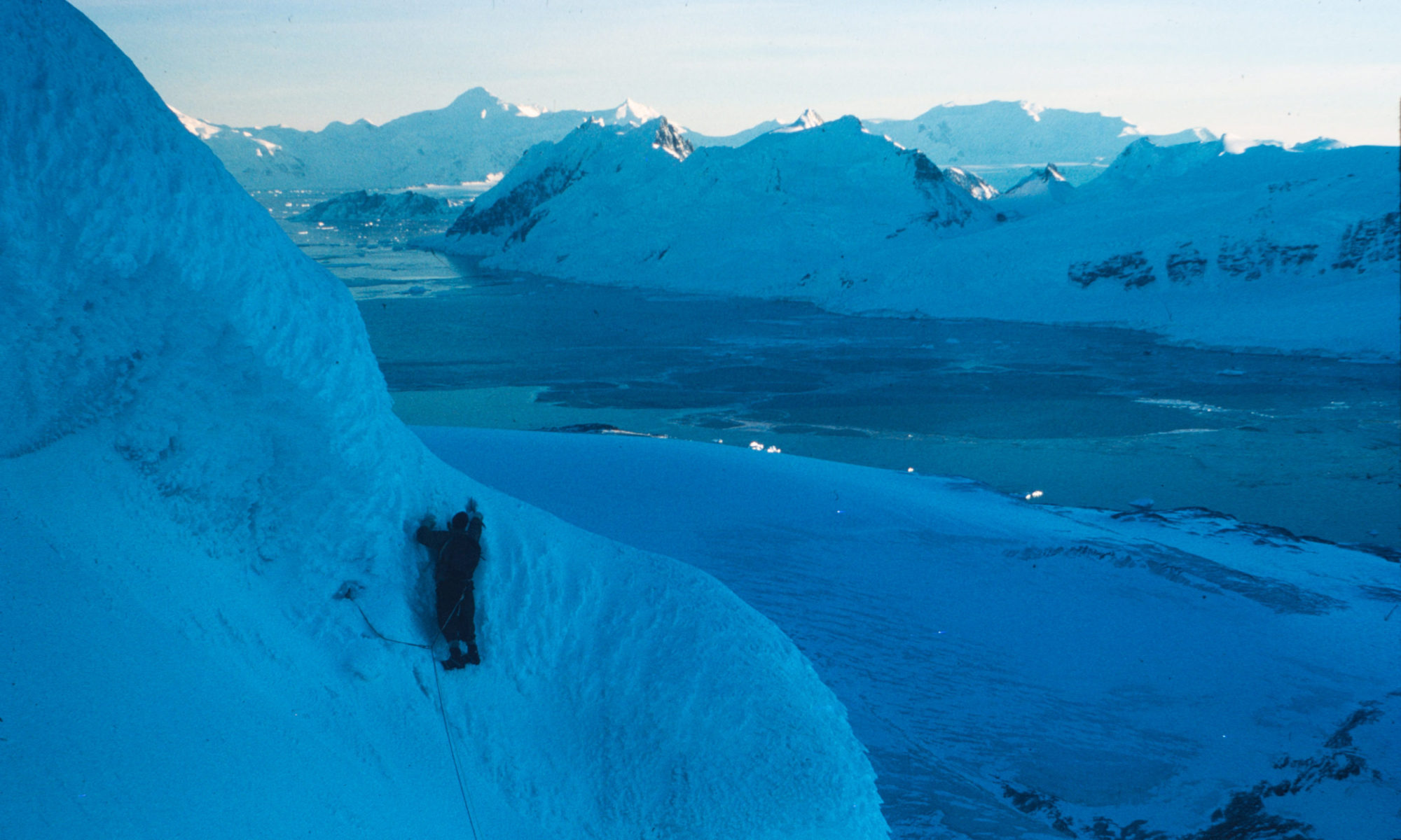
As we continued down the glacier the snow cover gradually increased such that they hid any holes that may have been there. The interpretation was that strong winds had stripped off the snow cover in the higher reaches and dumped it lower down the valley. We headed across the glacier towards the Carse Point Massif with everything looking good until we started crossing big holes again. Another plunge for Arri and Slioch, but the third time they weren’t as lucky because Arri wriggled and slipped out of his harness and plunged into the depths of a 15 ft wide crevasse, which was invisible on the surface. Sam also had a lucky escape landing on a secondary bridge and we hauled him out. Once we had probed all round us to find a little safe ground the teams were picketed and we set about trying to recover Arri. Chris abseiled down to the length of both climbing ropes but was still 20-30 feet from Arri who was still alive, whimpering, but there was evidence of blood on the walls of the crevasse. Eventually I loaded and lowered down the 0.45 revolver but swinging on a rope in inky blue-ness trying to put a shot into the dog proved impossible and reluctantly we had to leave him. It took another 1.5 hours to probe our way out of the morass of holes and we camped under the shadow of Carse Point about 9.5 hours after setting off in the morning, mentally and physically drained.
On the 3rd October, exactly 5 weeks from leaving Stonington and with me leading we negotiated the pressure ridges and odd crevasse (Isolde managed to extricate herself from a few) and then we were on King George VI Sound and headed for Ball Point. About 2 miles out into the Sound I saw in the distance the Muskeg and the “travelling circus” of the Fossil Bluff team. As we crested a rise the dogs saw them as well and at the gallop we reached the conglomeration of vehicles and tent/caboose and clatch! Jim and Jon had come across from Spartan Cwm on Alexander Island for the day to see us so it was quite cosy with 6 of us in the caboose, drinking rum, eating cake and blethering during the evening – these guys probably have never even seen sledging rations! Reaching terra firma or more correctly solidum glacies on the Sound and its level surface with no nasty crevasse surprises lurking for both man and dog, and temperatures only in the minus ‘teens rather than twenties or thirties was a great relief, tinged with the trauma and anguish of losing a dog. The following day we followed the Muskeg track to Calf Rock where Jim and Jon as Sledge Whisky had laid a food depot for us. A couple of days later we replenished our supplies and were extremely grateful to the efforts of Jim, Jon, Rog and Graham who had not only put in the sledging boxes, dog food and fuel but also contributed a few goodies – our meal that evening was oxtail soup with added peas, a small piece of meatbar, a crushed biscuit, paprika, a dash of bacon fat and a spoonful of butter, followed by meatbar, peas and baked beans with thick slices of brown bread and butter, and then raspberries and milk. Cake also appeared somewhere on the menu but that may have been the smoko. The guys from the Bluff really did us proud with the loaf and cake living as we had been with our carbohydrate intake limited largely to sledging biscuits. And we did not neglect our wonderful dogs outside the tent with two days of double Nutty. The temperatures were now a balmy -6C. It wasn’t until the 23rd October when the conditions improved from wind, snow and mank, and I actually got to touch some rocks at Tilt Rock.
The summer progressed and we were flown back from the Walton Mountains, Western Alexander Island to Adelaide via Fossil Bluff on the 8th February 1975.
Chris Edwards – Geologist & Doggy-man Stonington 1973-74
