Ice Navigation and Exploring the Southern Polar Seas – Stuart Lawrence
The frozen seas have given problems to navigators since antiquity with one of the earliest records being that of Pytheas of Massalia in 350-300 BC
Better known will be the voyages, between 1772 and 75, of James Cook RN who in HMS Resolution obtained a latitude of 71 10S, about 200km from the Continent of Antarctica, and who wrote on turning back north “I who had ambition not only to go further south than anyone had done before, but as far as it is possible for man to go, was not sorry at meeting with this interruption (consolidated pack ice) as it in some measure relieves us, at least shortened the danger and hardships inseparable with navigation in the Southern Polar Regions. Since, therefore, as we could not proceed not one inch further to the south, no other reason need be assigned for my tacking and standing north”.
Continuing from Ships Page…
This year is the 200th anniversary of the sighting of the Continent in 1820 by William Smith and Edward Bransfield RN in the brig Williams for we British; Nathaniel Palmer, in the sealer Hero, for the Americans, and Thaddeus Bellingshausen, in the Vostok, for the Russians.
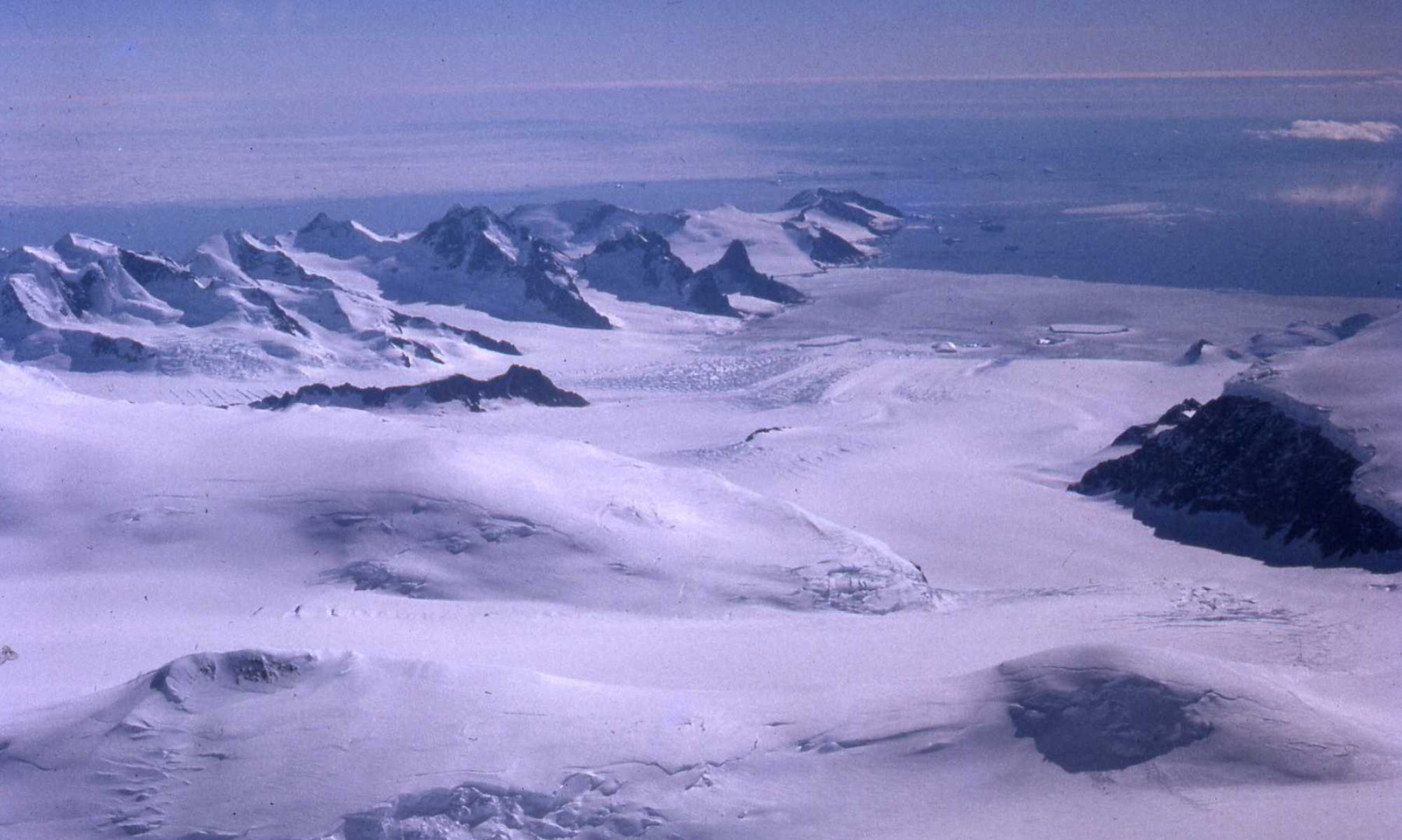
In 1823 James Weddell obtained 74 15S with the tiny Jane and reached Beaufoy, in what is now known as the Weddell Sea, a truly remarkable achievement as this position was only about 300 nmiles north of where Ernest Shackleton’s Endurance was crushed by the ice and sank.
In 1841 James Clark Ross with the Erebus and Terror ( later lost in the Northwest Passage) on the opposite side of the continent encountered the great ice barrier, that now bears his name, in 78 04S, whilst searching for the southern magnetic pole.
At the turn of the 20th century a Scot, William Speirs Bruce, in the Scotia and a German, Wilhelm Filchner in the Deutschland obtained the southern part of the Weddell Sea and eventually after being beset for many days drifted into open water.
In 1914/15 Ernest Shackleton in Endurance, became beset in 76 34S in the southern Weddell Sea from whence the Weddell gyre carried then north to 69 05S where she was eventually crushed and sank. Recent attempts by the latest South African research ship to search for the remains failed due to the concentration of multi-year pack ice in the vicinity preventing access to the very precisely calculated site.
In 1955/58 Dr Vivian “Bunny” Fuchs led the Commonwealth Trans-Antarctic Expedition from Shackleton Base 78S 37 30W with the aid of the Theron and the Magga Dan, whilst being on a sabbatical from his position as Director of the Falkland Island Dependencies Survey (later British Antarctic Survey, BAS) and Sir Edmund Hillary led the “support” party from Scott Base 77 50S 166 45E with the aid of HMNZS Endeavour. Sir Vivian crossed the continent, a distance of 3500 KM in 99 days.
These last reports had a great significance to myself as Master of the British Antarctic Survey, initially under Sir Vivian Fuchs, of the ice-strengthened Royal Research Ship Bransfield, for the period from 1973 to 2003, and utilising, at least for the first part, the route that Ernest Shackleton had followed from the Island of South Georgia to the Survey’s most southerly scientific station named “Halley” after the great British astronomer, geophysicist, mathematician, meteorologist, and physicist, at 75 35S 26 30W. Halley started life as a Royal Society Base in 1955 with the aid of the Totton; and is situated on the Brunt Ice Shelf in the south-eastern Weddell Sea. After two years it was handed over to the Falkland Island Dependencies Survey, later BAS.
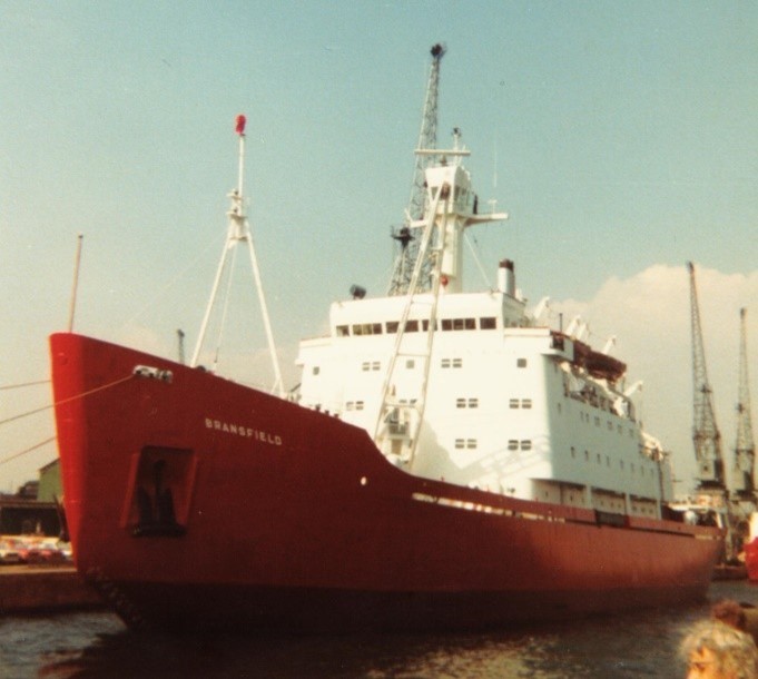
The RRS Bransfield was the BAS logistics vessel supporting the five scientific stations operated by BAS in the Antarctic, whilst the RRS John Biscoe, in addition to some logistics, carried out most of the marine scientific work. Bransfield, 4816 grt, 1577 nrt, launched at Leith 1970, of Lloyds 100 A1 Ice Class 1 classification, 325 ft in length, 60 ft beam, 22ft draught, service speed 13.5 knots. Diesel electric propulsion with control-able pitch propeller. The bow plating was 32mm and shell plating 28mm.
To give some idea of the power of pack ice I have been beset for 30 days, keeled over by 20 degrees and had the stern lifted clear of the ice!
In the early days little had changed in polar ship operations since the early pioneering days and it was not until the arrival of satellite navigation, satellite communications, satellite imagery and latterly the use of drones, that the planning and operation have become so much more sophisticated.
However the general rules remain the same. The appreciation that sea ice is an obstacle to any vessel, even an icebreaker. All watchkeeping officers should preferably have some hands-on experience or at least have successfully attended one of the Ice Navigator courses that are now available around the world. Well found vessels, in capable hands, can operate successfully in ice covered waters.
The first principle of a successful passage through ice covered waters is to maintain freedom to manoeuvre. Once a vessel becomes beset she can only go where the ice goes. Operating in ice covered waters requires great patience and can be a very tiring business. The ice free, long way round of any area of concentrated pack ice is always the quickest and safest route. When navigating in ice covered waters the following golden rules always apply:-
- Passage plan as far as possible to give the maximum daylight hours in areas of drift ice
- Keep moving even if only very slowly
- Always reduce speed or stop in poor visibility and during the hours of darkness, taking good account of the limited range offered by searchlights
- Radar is excellent at detecting the whereabouts of pack ice but not the concentration
- Radar is also good at detecting icebergs, but not bergy bits and growlers
- Try to work with the pack ice movement not against it
- Knowledge of your vessel’s manoeuvring characteristics and turning radius are vital
- Excessive speed leads to damage
- Be very aware of the difference between ice of land origin and sea ice
- Always attempt to achieve a right angle approach to any floe
- Avoid passing near or between heavy floes to decrease the possibility of ice impacts on the side shell plating
- Always steer into the heavier floe to prevent the bow swinging toward the lighter floe, thus exposing the side plating to the heavier ice
- Ensure the rudder is midships before making any sternboard
- Avoid anchoring in moving close pack
- Remember that if you are barely moving in heavy pack ice, all icebergs are ‘relatively’ stationary and that the relative motion is that of the ship and the pack ice
- The downward drift and leeway of pack ice around an iceberg will leave more open water on the leeward side of the berg.
- Always carry your camera as there can be some spectacular shots of icebergs at twilight and with the midnight sun!
Captain Stuart J. Lawrence MBE RD RNR MIoS