
1975 Air Supported Survey from Stonington – Roger Scott
Each year the survey team always relied on the support from the two Twin Otters for help with the summer survey. It speeded up the survey many times over compared to sledge travel between stations and more importantly it enabled lines to be measured that could either be difficult or maybe impossible to measure using surface travel. This year was no different.
Some air support had been provided near the start of the summer season when the survey teams were working over on the east coast in the area of Three Slice Nunatak however the main support was required to measure survey lines on the east coast of the peninsular between 72° and 73°. For the integrity of the survey it was important to get a traverse up the east coast from a US station, Aileen, on the plateau to tie in with a previously established station, Hotel, just on the north side of the Hilton Inlet at 72°.
Continuing from Topo Survey Page….
As with much of the east side of the peninsula many glaciers flowed west to east down from the plateau onto the Larsen Ice Shelf creating barriers for any north / south travel. A reconnaissance had already been completed on the 30th December 1974 with Giles Kershaw in FAP. At the time the survey party was based at one of the old American Jamesway hut field bases on the Peninsula, where much had been left behind in the way of food and assorted other bits and pieces. My diary entry for 30th says that on arrival I gave Giles a short guided tour of the largely buried American base hut and ‘he walked off with two rolls of soft toilet paper, a tin of snuff, a wooden toy flute and several others odds and ends’. What does this say about BAS toilet paper?
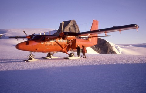
Survey recces were always good fun but you had to try and fit in as much as you could in a what was usually a short space of time. For survey lines it was necessary to be able to see from the top of one peak to another some 20 or 30 miles away. Looking from above at a spectacular landscape was all very well but intervisibilty between stations was the key point. There was no point in establishing survey stations if you could not see between them to measure angles and distances. So the method adopted was for a potential survey station to be identified (usually on a summit of rock, never on snow) and then for the plane to make a pass of the station flying at the same height as the station and as close as possible. This would preferably be done in several directions with the surveyor in the passenger seat trying to observe as much as possible in the few seconds you passed by the station. As this was before digital cameras you had to use visual observation – there was no other way. The surveyor always wanted to pass as close to the station as possible and Giles usually obliged. With knowledge from the recce we could now plan a survey and wait for fine weather.
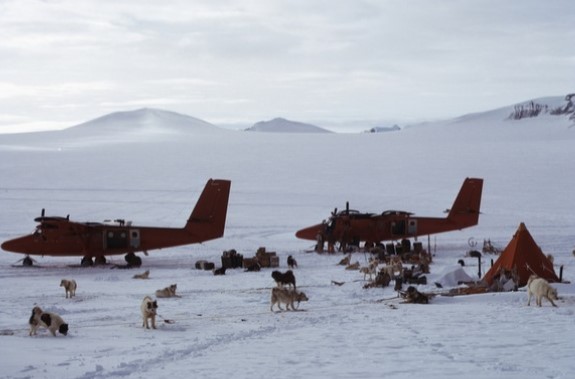
Usually the air supported survey was done by just one plane, but with both planes potentially available it was decided to use both together for the survey as it would enable much quicker work in a restricted weather window. The planes arrived on the 5th of January with Giles Kershaw in FAP and Bert Conchie in FAQ. Over the next few days the weather and dreaded ‘Larsen mank’ (low cloud that regularly formed over the Larsen ice shelf off the east coast) caused us a few problems but the occasion was notable for the fact that both planes with their field crews spent three nights and days in the field together (see header picture). This was only the second time that this had happened as it was generally considered unwise to have both planes on the ground together in case bad weather or other issues prevented either or both planes flying to an emergency elsewhere with other field parties. The first time both planes had spent a night in the field together was on 24th October when they were preparing to fly both survey teams down to the southern work area from the Three Slice nunatak area.
In the end no work was done for three days and then one plane had to return to Adelaide to help with the arrival of the Bransfield. So the whole survey was completed with just one plane but took a total of thirteen days of which only three days were actually survey work and the rest we were waiting on good weather. Far longer than would usually have been anticipated.
Roger Scott – Surveyor – Stonington 1973 & 1974