
The Start of a New Era at Rothera Point – Jonathan Walton
In late January, 1975 I had finished my glaciological work for the season. Most of our work was on or around George VI Ice Shelf and 4 of us had spent the winter at Fossil Bluff. It was the only way to get our studies done as during the summer the surface of the ice shelf became impassable with really soft surfaces, and melt pools several metres deep.
Steve Wormald called me on the radio – it was his first season as Field Operations manager at Adelaide, heralding major changes in scientific work on the peninsula. From now on, most scientists would be summer only, enjoying the winters back in the UK. We had had a great winter at Fossil Bluff – Jim Bishop, Graham Tourney and myself there as Glacios with the indefatigable Rog Tindley as our GA/Mechanic. We travelled large distances during the winter across the mainly flat and mainly safe ice shelf, entirely with Skidoos or our 3 Muskegs (yes 3!, named Fred, Aphrodite and Blodwen). We still retained a link with the days of yore via our elderly pet husky Rasmus but sadly he had died on the 2nd of August 1974, we think the oldest husky to still be active in the Antarctic. Active is perhaps a misnomer – on a good day he could stagger up to high street from the main hut to the garage – his 12th birthday was just a memory for him.
But I digress. It is very easy.
Continuing for Rothera Page
Steve asked me if I, as a trained land surveyor, would be able to produce a map of Rothera Point as BAS were considering building a new base there to replace Adelaide whose runway was nearing the end of its useful life. He asked if we had the kit. I said I would be happy to take on the task if I could take Graham Tourney as my oppo – we had got pretty used to each other over the winter, we got on well and he was a trained civil engineer so certainly knew his way around a Theodolite.
So off we flew to Adelaide. After the peaceful existence at the Bluff it wasn’t long before we wanted to turn round and head South again to our home – both of us were to stay on for another winter at our precious little outpost of humanity on Alexander Island. Our total equipment amounted to a Theodolite, a 100metre tape, an optical level, a 4metre levelling staff plus about 20 x 2ft long wooden pegs and some bamboos with flags on. Also quite a number of small blank surveying notebooks. Not a single battery or electronic instrument in sight.
We had brought one of our own tents from the Bluff and in due course we were flown to Rothera. We were given a skidoo and Nansen sledge to save us having to walk down to the point from the Skiway, about 4 miles away. And so we descended down what seemed an impossibly steep ice ramp to encounter this apparently immense area of real ground – certainly the biggest area of rock and soil we had seen for over a year. The tent was pitched – next to the old sledging depot (somewhere near where the Skidoo racks are now I think). I will never forget our first evening. It was warm enough to sit outside the tent and just look at the view in front of us which we were sharing with no-one else. Of course there was a short conversation along the lines of “well, how long do you think we can spin this out for” but there was also a sense of urgency as the finished map had to be drawn before the planes left at the end of February, by which time we wanted to be well ensconced back at Fossil Bluff. Our first day we just walked the site. An old surveying adage is that “Time spent in reconnaissance is seldom wasted”. We really couldn’t believe our good fortune to be isolated here for as long as it took, away from the hurly burly of the Marguerite Bay Summer season.
However, being responsible citizens we duly set to work. Our task was simple – to map the entire point including a cross section up the ice ramp, look for an optimum line for a possible runway and survey a long section and multiple cross sections of that runway line.
Essentially, the art of producing a map of a relatively small area like Rothera Point is to establish a network of Fixed points (wooden pegs!) hammered into the rock or shingle and carry out enough measurements to be able to know accurately the position of each of these points relative to the other ones. Having no fancy machines for measuring distances, we set out a baseline on the (fairly) flat area where the beach is now – just under 100metres, the length of our tape. From this we could “triangulate” using our theodolite, all the other stations, building up a network of interlocking triangles. On the far side of the rocky headland we established a check distance between 2 wooden pegs that we had triangulated and, “phew” it all seemed accurate enough. From there we had to occupy each of our wooden pegs with the theodolite, measuring a horizontal angle, vertical angle and distance to any number of relevant topographical features. Edges of bedrock, significant changes of slope or height etc etc. About 700 in all for the whole Point.

It was impractical to clamber over Rothera point, being mobbed by Skuas, while trying to stretch out a 100m tape measure. Which was where our 4m levelling staff came in handy. Using an age old technique known as tachymetry, we could line the telescope on the face of the staff which was marked in 1cm units. Record the reading on the staff of the upper and lower crosshairs of the telescope, multiply it by 100 and magically you get the distance. Not superbly accurate, no better than +/-10cms but it was good enough for what we needed. We had a number of magical days doing our own thing on our own desert island. We worked hard, we ate well, we slept well. I think I recorded in my diary that one night we had to tie up the door to the tent as it was a bit windy – but left it open every other night as we didn’t want to waste a single opportunity of looking out of the door to an ever changing view as the bergs scudded by.
The Point was rich in wildlife at that time having been relatively undisturbed. Occasionally we had to ask a recalcitrant Weddell seal to “move along there” as he (or she) was lying just where we wanted to put our measuring staff. Skuas aplenty dived us – we ended up just walking around with a ski stick sticking above our head and tied to a rope belt. Another memory is of waking up one morning to see a curious Adelie looking in through the tent door.
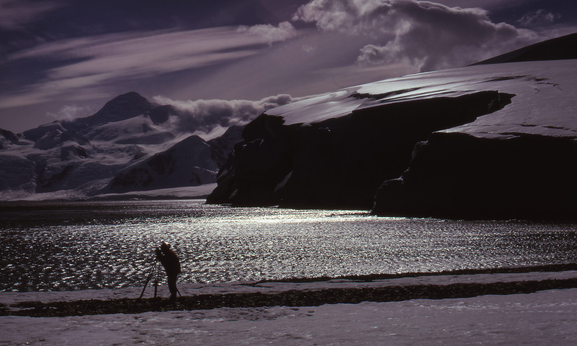
I well remember one memorable evening surveying on South Beach when the light was just superb. 2 years later, Graham presented me with a magnificent Cibachrome print of the photo he took (as a thank you for acting as his “Best Man”). I have been informed by my nephew that a copy of the photo still sits in the Rothera bar area in late 2019! In between measurements we snaffled the odd remnant of food from the old depot, dating back to John Rothera’s time in 1961. We preferred the newer rations.
Half way through our endeavours we were alerted to a particularly good forecast for the following day. We were instructed to be up at the airstrip at a certain time where a Twotter would come and whisk us, plus a couple of other Glacios, up to February Snowdome on the plateau for a short day of ice-drilling, bringing out a core of ice for oxygen isotope analysis, the very early days of this sort of climate change study. With memories of 22 wind-bound days marooned on this dome the previous year we were relieved that the plane stayed with us – we were very keen to return to our task and cosy home at Rothera Point. But it was nice that Bert Conchie the pilot accepted our invitation to come down to the Point for a cup of tea. Yet another memorable day.
All too soon the measurements were complete – now the hard graft began. With space at Adelaide at a premium due to the arrival back of a number of field parties, Graham and I were whisked back to Fossil Bluff. Doing the calculations with a laptop nowadays for this type of survey with a network of 12 control stations and 700+ separate points of detail would be easy. Doing it in 1975 was hard work although we were fortunate to have available an HP35 calculator, the very first pocket calculator that could calculate sines and cosines, essential for all the triangulation and also for every one of the detail points. Jim Bishop had ordered this from the UK the previous season – at his own expense (£189 – bearing in mind we were earning around £145 per month!). We had used it through the winter season and regularly had protracted mathematical radio conversations with the Surveyors at Stonington who with dog teams were working on the overall mapping of the peninsula but who still had to use 6 or 8 figure log tables and windy-handle mechanical calculators. It took us 2 days or so of hard work doing the sums then we commandeered the Kitchen table in the Bluff as a drawing board. Actually we drew on a smooth sheet of plywood so we could evacuate the “dining room” at meal times. Seeing as pressure was still on, for the first and only time Graham and I were excused all gash duties until the map was finished.
We duly compiled a map of Rothera Point, all hand drawn and even produced the required set of cross and long sections for the proposed runway.
And then, right at the end I made my big mistake. I knew the magnetic variation of Rothera Point but applied it the wrong way so the spine of the point appeared to align N-S, rather than SSW-NNE. I never realised my mistake until I returned to Rothera base in November 1978, by then a thriving logistic facility, and saw my map, mounted and framed, on the entrance hall wall. My North arrow had been carefully scratched out and a new one inserted to align Rothera Point in the correct direction. Apparently that correction is still visible in the map on the wall at Rothera. Thankfully my mistake didn’t cause great embarrassment – it meant that the proposed runway was now oriented almost due N-S, just right for the prevailing wind. I remember calculating from our cross section that we could just fit in a runway of 600metres length on the point. The current runway is 900metres. I had no idea how much rock and earth moving was going to happen to achieve this.
One offshoot of this episode was that when my father (Kevin Walton, a 1946-48 Stonington FID) told me of the new house he was building on the side of the Malvern Hills and described the highly insulated material called “Structaply” being used for the construction, I suggested that he contacted Al Smith, then the Buildings manager for BAS – I thought they might find the material interesting for Antarctic use as they were considering installing a new base the following year. 8 months later I heard that the first 2 Structaply huts had been loaded on to the BAS ship (the John Biscoe I think) and were on their way south. The first one ended up at Damoy where is served a very useful purpose until 1993 when the hard runway was constructed at Rothera. Indeed it still serves a useful purpose as a picturesque site for ship-bound tourists to see how life was like for those intrepid 1970s Antarctic explorers! The other one ended up at Rothera of course. When I finally left Fossil Bluff, bound for the UK, in March 1976, Graham and I spent a couple of weeks at the very small “Rothera Phase 1”. Being 48ft x 20ft it felt palatial after Fossil bluff but there were 13 other temporary inhabitants (in one bunk room!) so it was a very jolly but not quiet place for an end of season stay. But somehow our surroundings didn’t have the magnificence it had when there were just the two of us there. It would never ever be like that again.
All of our endeavours had taken place with neither Graham nor I having any idea that Rothera Point was in fact the originally intended site of what became Adelaide Base – in 1961 – but the ice didn’t let the ship through that year.
A couple of years ago I was reading my copy of Fossil Bluff’s base diary for 1975. One entry made by Rog T near the end of our map drawing on the kitchen table read (from memory) “the map of Rothera point was completed today – they are talking about building a new base there. A really steep Ice ramp and the airstrip several miles away – hardly ideal so based on Head Office’s usual logic it is probably a dead cert!”
Well, Rog was correct – but how wrong we were in not realising the massive vision that BAS had in those early days. –
Jonathan Walton – Glaciologist, Fossil Bluff – 1974 & 1975