
THE ESTABLISHMENT OF DAMOY POINT REFUGE HUT – Bernie Care
( Location! Location! Location!)
The author and about ten other Fids (scientists, builders and GA’s) arrived off Doumer Island at the northwestern end of the Antarctic Peninsula in late October 1975 after sailing down on the RRS John Biscoe from Southampton via Argentina and Port Stanley. The plan was to fly from the Doumer airstrip to Adelaide Island, and from there onto our respective summer work areas – but first we had a bit of building to do!!
The Biscoe was carrying material for a refuge hut (staging post) to be built near a proposed new airstrip at the extreme southwestern point of Doumer Island. This site had been visited in April 1975 by a party from the Bransfield during her return trip to the UK, looking for alternate airstrips with easier cargo/personnel landing sites than the existing airstrip located in the center of the predominantly snow-covered island. The existing airstrip was found to be inaccessible for skidoos, but a suitable location was found on the southwesternmost peninsula of the island close to the un-manned Chilean Base Yelcho. The report findings are attached below.
When the proposed new landing and airstrip sites were visited from the Biscoe in October 1975, deep soft snow conditions unsuitable for both aircraft and skidoo access were found.
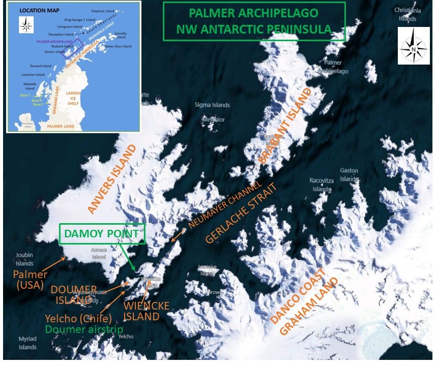
After further sailing around the area, an alternative location was chosen at Dorian Bay about 5 miles to the north on the west coast of Wiencke Island adjacent to an existing Argentinian refuge hut (Bahia Dorian). This location had a gently sloping pebbly beach suitable for offloading launch/scow loads of personnel and supplies. Furthermore, the site offered easy access to an extensive elevated and relatively flat snow piedmont to the south. This feature formed the spine of an approx. 0.75-mile-long peninsula orientated WSW to ENE between a rocky ridge leading up to the highest peaks on the island in the east and with an open water (or sea ice) approach from the west. The restored British base of Port Lockroy is in the bay immediately to the south of the airstrip, and nowadays a popular tourist trap in summer months when it is manned as a post-office.
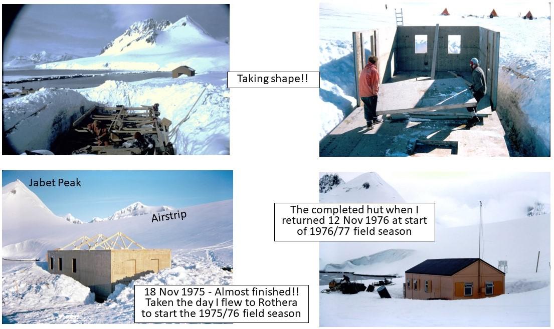
The following is a pictorial account of the building of the Damoy Hut, together with a brief history of the place names in the vicinity, which most Fids who sailed to the Peninsula will probably recall.

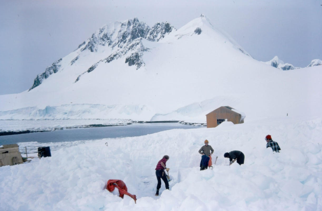
After 5 two-man pyramid tents were erected to provide accommodation for the building “crew”, the prefabricated floor and wall panels (clearly stamped BAS/DOUMER), other building items for the hut, food stores and avtur fuel drums for the airplanes were brought ashore under the supervision of builders Andy Turner and Colin Horton.

Digging then commenced (Fids and shovels) at a location about 150 ft southwest of the Argentinian refuge and bedrock was reached at a depth of 6 to 8 ft, upon which the concrete foundation piers were positioned and levelled. No mechanical aids were available to the Fid-diggers, but a concrete mixer sped up completion of the foundations. By mid-November, the shell of the hut was complete with roof trusses installed and the Fids were flown south to Adelaide by the Survey’s two twin otters and then onto their respective summer work areas. This left Andy and Colin to tidy up, weatherproof and secure the hut before they too flew south to Adelaide for their next projects – constructing a floating jetty for, and completing the Phase 1 building of, the new Rothera Station.


Origin of place names in vicinity of Wiencke and Doumer Islands:
Palmer Archipelago-Adrien de Gerlache, leader of the Belgian Antarctic Expedition (1897–1899), discovered the archipelago in 1898. He named it Archipelago Palmer for American Captain Nathaniel Palmer, who navigated these waters in 1820
Brabant Island-named by the Belgian Antarctic Expedition (1897–1899) under Adrien de Gerlache, who named it after the Belgian Province of Brabant, in recognition of the support given to the expedition by its citizens.
Anvers Island-was discovered by John Biscoe in 1832 and named in 1898 by the Belgian Antarctic Expedition under Adrien de Gerlache after the province of Antwerp in Belgium. Anvers is the French name for Antwerp.
Gerlache Strait-the Belgian Antarctic Expedition, under Lt. Adrien de Gerlache, explored the strait in January and February 1898, naming it for the expedition ship Belgica. The name was later changed to honor the commander himself.
Neumayer Channel-the southwest entrance to this channel was seen by Eduard Dallmann, leader of the German 1873-74 expedition, who named it Roosen Channel. The Belgian Antarctic Expedition, 1897–99, under Gerlache, sailed through the channel and named it for Georg von Neumayer. The second name has been approved because of more general usage.
Wiencke Island-was named by the Belgian Antarctic Expedition, 1897–99, under Adrien de Gerlache, a Russian seaman fell over and Carl August Wiencke, a Norwegian seaman saved his life but then lost his life after saving him.
Damoy Point-was roughly charted by BeAE in February 1898; further charted by FAE, 1903-05, and named Pointe Damoy after M. Damoy, Paris dealer who provisioned many expeditions
Jabet Peak-was probably sighted by BeAE in February 1898; roughly mapped by FAE, 1903-05, in 1905 and named Pic Jabet after Jacques Jabet, boatswain in the expedition ship Français, who climbed in the area
Harbour Glacier- was probably first seen by the Belgian Antarctic Expedition, 1897–99, under Gerlache. The glacier was charted in 1944 by the Falkland Islands Dependencies Survey, who so named it because of its proximity to the harbour of Port Lockroy.
Port Lockroy-was charted by FAE, 1903-05, on 20 February 1904 and named Port-Lockroy after Etienne-Auguste-Édouard Lockroy (1840-1913), French politician who helped to finance FAE
Goudier Island-was charted by FAE, 1903-05, and named Îlot Goudier after E. Goudier, Chief Engineer in the expedition ship Français
Doumer Island-was charted by FAE, 1903-05, and named Îlot Doumer after Paul Doumer (1857-1932), French statesman and President of the Chamber of Deputies, 1905, who helped to finance FAE; President of France, 1931-32
Yelcho Base-named for the Yelcho that was commanded by Luis Pardo, who rescued members of Shackleton’s Expedition from Elephant Island in1916 after Shackleton had sailed to South Georgia and then crossed the island to a whaling station for help.
Bernie Care (Geologist: Stonington 1974/75, Adelaide and Rothera 1975/76 and 1976/77)