
Seventy-eight Feet on a Walk in the Antarctic (continued)
Being an account of a very ordinary Sledge journey by three men and eighteen dogs
Sledges: Two; John Graham with ‘The Counties’ and Frank Oliver with ‘The Komats”
Counties: Jaikie (leader), Lance, Freda, Hamish, Hassan, Sleek, Yap, Beds, Herts
Komats: Rufus (leader), Till, Dusty, Dawn, Tam, Porgy, Steve, Castor, Rogue
On 4 October 1958 the weather at base was cloudy with a warm northerly wind (temperature 29°F or –2°C) and it was decided to make a start. There had been much snow and high temperatures the previous two days and we were not expecting the surface to be good. The sledges were loaded, lashed up and taken down to the starting point, referred to as the landing stage although nothing of this was visible as the island’s boundary with the frozen sea was merged by the thick snow and only hinted at by cracks an inch or two wide caused by the rising and falling tides. At this juncture, however, it started to snow heavily and visibility was reduced to a few yards, so parts of the loads were removed and we returned inside the base hut. After lunch the snow stopped, although the weather was otherwise unchanged, and in the afternoon the loads were re-lashed, the dogs harnessed and our departure effected without mishap at about three o’clock. Once clear of Detaille Island surfaces were better than we had expected so that we could be towed on skis, but when we came level with Andresen Island (which we kept on our right) the snow was soft and it was only slowly and laboriously that we progressed, all of us working hard and sweating freely in the unusual mildness. Several seals and some pups lay near the coast of Andresen; in the area of base the winds must have been too fierce for them. A slight improvement in the surface as we left the shelter of Andresen Island made it necessary to try to slow down ‘The Komats’ who were following in the tracks of ‘The Counties’, so I went and ski-towed while Frank sat on the sledge. About two-thirds of the way from Andresen to the mainland we passed several large icebergs around which seals were lying, so in case there were none within easy reach of the hut it was decided to kill two and haul them the rest of the way. It was unfortunate that the pupping season was at its height and the only beasts were mothers with babes which nevertheless had to be shot. The surface became worse again as we approached the mainland; I went ahead to make a trail for ‘The Counties’ followed at some distance by ‘The Komats’.
There is a permanent crack in the ice just before the refuge hut is reached which, although presenting no great difficulty to me on skis or to the sledge, caused the loss of a seal pup. After a few crossings in quest of seals (of which, as it turned out, there were several near at hand), the edges of the crack wore away and most of ‘The Counties’ had a swim, and John went in up to the thigh twice.
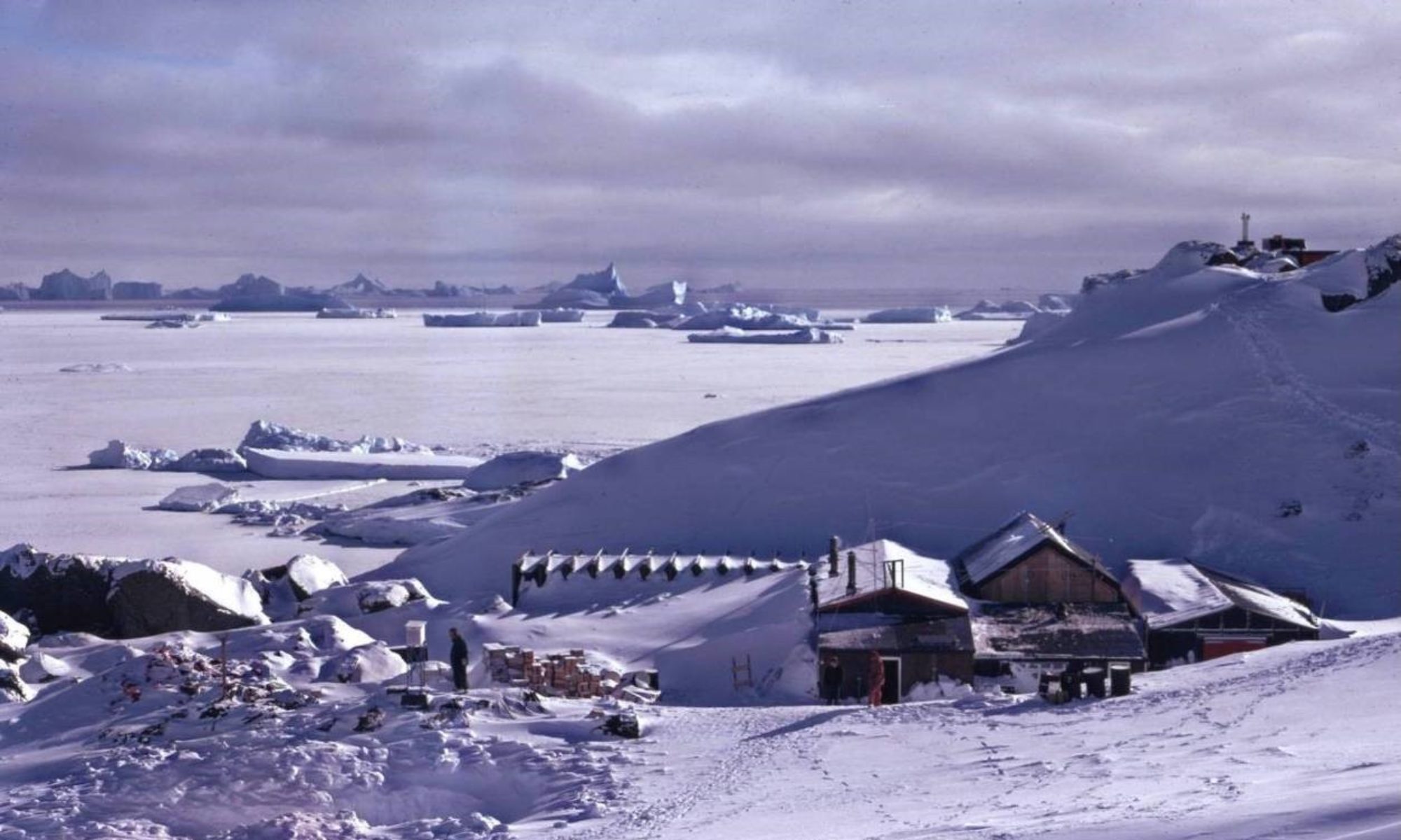
The refuge hut faces north across a bay some five miles wide into which flows the Murphy Glacier and several minor tributaries. The coastline is mostly ice-cliff, but at the southern extremity of the bay is a rock outcrop backed by a very steep snow slope with a small area of approximately level ground at the foot on which the hut is built. This snow slope is the only known access to the Grahamland plateau from this side of Lallemand Fjord. The glaciers as they reach the sea are a chaos of seracs (blocks of ice) and the practicable part of the Murphy Glacier (some three miles up) can only be attained by working along the flanks of the hills to the south. From the hut, the first part of the route is too steep for sledges so that each box has to be carried up to an outcrop referred to as ‘Top Rocks’ at a height of about 250 feet (75 metres), and then the empty sledges have to be dragged up. The first 100 feet (30m) is so steep as to make crampons advisable. John and I had shared the transport of boxes of man-food, dog-food and paraffin on a previous visit to the hut in August. Above Top Rocks the slope is only slightly less steep for another 500 feet (150m) and the maximum sledge load that dogs and men could manage on an average surface was about 400 lb (180 kg). On our arrival I went in and prepared a meal whilst John and Frank cut up seal and fed the dogs. For cooking at the refuge there is one good primus stove and an elaborate double-burner of the same principle which, however, is half out of action. The range of food was virtually the same as at base from where it had been supplied, but since there is no oven and visitors are usually only passing through, the range of dishes is not very great.

My favoured creation was a fricassée made basically with a flour sauce to which is added salmon and lobster or stewed steak from tins plus flavouring and seasoning as available and as my small talent suggested. John was strong on ‘fry-ups’ (bacon, sausages and other meats plus onions and potatoes all thrown into the frying pan). Desserts were generally a simple matter of opening a can of fruit—pears were the most popular. There are only two bunks in the hut so John spent the first night on the table. I was lucky when we selected our used (and abused) sleeping bags because I chanced to choose one that still had a reasonable quantity of down in it. I was never cold in it, frequently too warm in the tent when the primus was burning.
Next day, Frank and I each man-packed three boxes up to Top Rocks and then got ‘The Komats’, their sledge and the one-man emergency tent (‘pup’ tent) up there via the Gully route with much coaxing from me in front. Frank announced his intention of sleeping in the pup tent at Top Rocks in order to keep an eye on his team and to relieve the congestion in the hut. The five days we spent at Johnston Point are now congealed in my memory into one, but between spells of northerly gales (in one particular hurricane the highest gust of wind recorded at base was 111 mph [96 knots or 179 kmh–1], with snow, sleet and rain and a temperature reaching as high as 37°F (+3°C) we managed to get the depot up to the top of the hill, myself leading to encourage Rufus and ‘The Komats’, with Frank pushing and bellowing behind, whilst John and ‘The Counties’ brought in 15 seals.

(Photo: Robin Perry)
On 10 October we were ready to start, and the weather looked as promising as could be hoped for. The first job was to get ‘The Counties’ and their sledge up to Top Rocks and it was accomplished without much difficulty. Then we carried up a few items of personal gear, packed the pup tent and went up to the depot at about 750 feet (230m) above sea-level. From there we had an excellent view across the frozen fjord to the mountains of the Arrowsmith Peninsula. Detaille Island is hidden behind the bulk of Andresen Island. Loads were made up of goods for the glacier, leaving half, or rather less, for the second relay. Except for the final leg, even with excellent surfaces we had to cover every inch of the way twice with at least one of the sledges. It was decided that the first leg would be to the middle of ‘Baseline Glacier’ (our unofficial name for a side glacier flowing down from the south); we would make a first trip and set up the tent there, then return for the rest of the load. After about half a mile of comparatively level ground (this had been used by the previous year’s occupants of the refuge for dog-training purposes), we climbed again to a height of about 900 feet (275m) above sea-level and then had to drop to about 400 feet (120m) on Baseline Glacier. Following a straight line the descent became too steep so that a left turn had to be made, and a traverse along the side of a ridge that runs down to the spur known as Buttress Camp. This caused John’s sledge to turn over twice and Frank’s once. After the delays needed to unlash, unload, turn upright, reload and relash, we got down to our planned camp site and pitched the tent (Camp I). It was a brand-new double-walled pyramid tent, spacious and stable, although it seemed rather dark inside (this is probably for those who find it difficult to sleep in the sunny nights of summer). Nevertheless, in normal daylight it is perfectly possible to read.
We then returned up the hill of accidents to fetch the remainder of the depot. Frank loaded with some goods for Buttress Camp whilst John took the rest of the plateau consignment. He went on alone to the tent and I accompanied Frank on the digression to the Buttress Camp cairn where there was already a pile of boxes brought by John and me during our August visit. As it was only about five o’clock when we were reassembled at the tent on the tributary glacier, we decided to push on with loads as far as the Murphy Glacier itself if possible, leaving the tent to return to later in the evening. The surface became good, in fact much too good when we found ourselves on a steep slope, having come too high. Both sledges went over when we tried to turn on the hard-packed snow, and as a northerly wind was increasing and raising drift, with menacing clouds to the north, we took our loads down to what appeared to be the best route on to the Murphy Glacier and deposited them, hurrying back to Camp I without making further reconnaissance.
John appointed himself cook and issued our rations: one bar of Cadbury’s chocolate, one packet of six Symbol expedition biscuits, and cooked our meat bar, packet of soup powder, ounce (30 g) of dried onion and seasonings in about two pints (one litre) of melted snow. To drink, there was tea or Nescafé (the latter we had brought in preference to cocoa). There was a large supply of butter and this was added to almost everything. That night the wind exceeded gale force from the north, bringing continuous snow and not making for peaceful sleep. In the early morning it backed round to west but continued to blow, bringing squally showers that roared on the fabric of the tent. There was no question of moving after breakfast, so we lay either comatose or reading in our sleeping bags until about 4.30 p.m. when the wind died and the sky towards the west became more settled, though still with heavy banks of clouds on Protector Heights to the north. We arose, struck camp, loaded and lashed the sledges and moved on to the depot we had left yesterday and set up camp again there (Camp II). It was Frank’s turn to be cook, so John and I attached ourselves together with about 100 feet (30m) of rope and prospected for a route down on to the Murphy Glacier. With no sun, details of the snow surface were invisible, but we agreed that a good route seemed to exist. We returned to the tent without actually going down because it started to snow with deteriorating visibility.

Next morning, however, we awoke to a scintillating sunny day with a temperature of 15°F (–10°C), just right for these conditions. With Frank cooking breakfast we made a good start soon after nine o’clock, leaving the tent standing. With fairly heavy loads we descended to the Murphy Glacier and found that the surface changed from hard-packed to soft loose snow, making progress slow and exhausting in the hot sun for the dogs, especially the dark ones. Along the left (south) bank of the glacier at this point runs a terrace of level and apparently uncrevassed ice. In spite of its innocuous appearance we decided that I should lead the convoy on a 90-foot (28-m) rope and test for hidden crevasses with a long pole. This had the incidental benefit of giving the dog teams an incentive to pull ahead. I had prusik loops in case anything opened up and let me down, but the visible holes were easily circumnavigated and my prodding never revealed traps. The heat was intense on the glacier and we wore a minimum of clothing, in John’s case a bare minimum from the waist up. The first load was taken some two and a half miles (4km) up the glacier to a point where we encountered a penetrating breeze that made us quickly reclothe ourselves. Returning through the heat we reached Camp II about three hours after setting out, and had a lunch break, being able to brew up outside with no difficulty.
Loading the tent and the rest of the gear, we made much better progress the second time and soon passed the first depot, intending to carry on as long as possible before stopping for the night. We had to pass beneath seracs poised ready to fall; the slope on our right that culminated in ‘Deuce Peak’ as we then called it (I believe the official name is now Tammann Peaks) is excessively steep and ideal for avalanches. About a mile and a half further on we camped at a point we hoped was out of reach of such hazards which audibly manifested themselves from time to time (Camp III). The mountain soared above us and the sun had set on this position some time before we arrived soon after six o’clock; the snow had readily melted on our mukluks and boots earlier, and now these were frozen stiff and all of us had cold feet. John had much trouble removing his mukluks. The temperature outside was 2°F (–17°C) and the breeze had strengthened somewhat.
It was my turn to be cook. This involves little initiative or effort and is not to be dreaded like cooking at base. Also there is no washing-up. Before settling into one’s sleeping bag, the requirements for both the evening meal and breakfast are removed from the two boxes which are then used as tables down the middle of the tent’s floor space. In spite of their hard day, the dogs were restless at first, possibly sensing danger from the mountain wall. But they settled down, and the night was peaceful.
We had expected an intensely cold dawn, but in fact the wind rose and the temperature with it. The reading outside as I cooked the porridge next morning was 17°F (–8°C). The weather was not so promising, but we could still travel.
So the first thing to do was to return for the depot lower down. This delicate passage was effected without mishap, and on returning to Camp III we added the camping equipment and pressed on, with me ahead again. At this point there is no real ascent; the area has been referred to as ‘The Basin’. The main glacier bends to the left and it was necessary for us to leave the terrace and cross into the middle, which meant negotiating a crevassed zone, but it was not difficult. Even with their heavy load, ‘The Counties’ kept catching me up and had to be held every few minutes to let me get to the end of my tether.
Generally speaking, our huskies reacted to only four commands: to start, to stop, to turn left and to turn right. Phonetically, these were respectively: Weet!, Aaaa!, Irrrrra! and Owk! There is no provision for half-speed or reverse. We were heading into a wind that raised drift to a height of a couple of feet (60cm), and as there were definite signs that it was increasing we stopped and put up the tent at about one o’clock, having passed the area we had been warned might be tricky (Camp IV).
Soon the wind had increased to gale force and the drifting snow was high enough to hide all but the mountain tops. No more sledging today. That evening we had arranged a radio schedule with base, so before entering the tent I erected an aerial in the form of a 100-foot (30-m) length of wire suspended through the hand-loops of ski-sticks and leading into the tent through the ventilator. Our station call-sign was ‘Altocumulus’, or AC on the key. Even at this early stage a shortage of reading matter was experienced by the others. I take so long reading a book that I was not yet affected. Shakespeare asked rhetorically ‘Who can wallow naked in December’s snow by thinking on fantastic summer’s heat?’ and I was experimenting by reading Desert and Forest (Nesbit) which describes a journey made in Ethiopia where temperatures of above 150°F (65°C) were experienced. When the primus is burning the interior of the tent becomes extremely warm, and comfort can only be found by lying flat while outer garments dry suspended from near the apex of the tent.
At 8.30 p.m. I tuned in and heard Colin Johnson at base calling us and another sledge party, Denis Goldring and Paddy White who were geologising around the coast of Lallemand Fjord. Reception of sledge radios at Base W is notoriously bad, so I was glad to hear Colin answer my call, even though it was too weak for ‘fone’ and transmission from our end had to be by key. I sent a brief note on our position and progress and heard the news from base. Paddy could not make himself heard (he later told me that he had heard me on his set, though not readably). During the early part of the night the wind roared fiercely around our tent, but at some time in the small hours I awoke to a silence broken only by the heavy breathing of the others. Then, faint but distinct, I heard a delightful tune played on an instrument that sounded a bit like the Northumbrian pipes. I wondered if I had left the radio on, but on investigation found it to be well and truly switched off. The music seemed eminently suited to mountain sprites inhabiting the great corries on Sickle Peak, now called Mount Goldring. Once mundane reasoning had established that the melody was created by the breeze in the taut guy-ropes of the tent, it was most somniferous.
By breakfast time, however, the gale had renewed so that nobody left the tent and made the best they could of the available literature until about five o’clock which is the time John and Frank go out to feed the dogs. The wind had abated somewhat, and John came and averred that it should be feasible to return for the depot at the previous camp-site under Tammann Peaks, so I dressed and emerged into the elements which were certainly not as bad as they had sounded from inside. There was no need for both sledges to go, so Frank and ‘The Komats’ stayed at camp. No fresh snow had fallen and our tracks were plain to follow so there was no need for me to be ahead route-finding. It was about 6.30pm when John and I returned to the tent with the load, by which time the wind had fallen almost completely, enough for me to do a round of compass angles on prominent peaks to try to locate our position a little more precisely, though accuracy is a relative matter here where no detailed topographical survey has yet been made. Frank had a meal ready.
Next day there was little wind and the sun was shining through a sheet of cirrus cloud, so we broke camp and, in the usual manner with myself ahead testing, progressed a further five miles (8km) up the valley to the junction with ‘Knight Glacier’ before the wind once again made us put up the tent in the early afternoon (Camp V). Although conditions up the main glacier looked rather ominous, John and I set off to return for the remaining load, hoping to get back to Frank and the tent before the weather broke. I should add that the relay load always included the pup tent and duplicate food and utensil boxes, so that if we were caught out we would forfeit no more than a degree of relative comfort.
The wind around here seemed to be even more boisterous than before, and I am convinced that the tent withstood gusts to hurricane force (Force 12) during the night. They were often preceded and followed by an eerie silence.
At breakfast time it was still blowing hard and nobody ventured outside even though the sun, as we could tell, was shining through the flying drift. By lunch-time, though, we had become so disgusted at lying in our bags, and the wind did seem to have abated a little during the morning, that we crawled out into the dazzling brightness and decided to push on a little further, even though it would be still into the wind. It remained gusty and produced whirlwinds of drifting snow that rose to a height of 70 to 100 feet (20–30m) like miniature white tornadoes. It was unpleasant enough for us, but it must have been much more so for the poor dogs at whose level the drifting snow was driven relentlessly. We left the tent standing and took loads another two and a half miles up, then returned to the camp, dismantled it and managed to repitch the tent at the forward depot without too much difficulty (Camp VI). During the night the gusts diminished in violence and frequency, and by six o’clock next morning it was calm, though cloudy. I know, because I had to get up to attend to a dog that had slipped its chain and was considering eating the tent.
In doing so I made such a commotion that the others awoke and John felt obliged to start cooking breakfast. Thus we made a reasonably early start, taking the larger part of the load plus the tent. There was a slow climb at first, but the refreshed Counties on the excellent surface still managed to catch me up with their 900 lb (410 kg) load. The route then levelled off as we crossed an influent glacier from the left, before starting a long and steep climb that left John and the dogs exhausted and forced Frank to depot part of his load. During the climb we had vertical cliffs on either side, red rock on the left and black on the right, and down these fell avalanches of varying severity every few minutes; although we were well away from them, a cloud of ice particles billowed up as they hit the foot of the crag, and miniature blizzards were produced as these clouds were carried by light winds into the middle of the glacier. When at length the gradient eased off and we could see the route ahead, we pitched camp and had some refreshment, the time being about noon (Camp VII). Our altitude here must have been about 5000 feet (1520m), so that we had climbed about 2000 feet (610m) from Camp VI.
At last we felt we were getting somewhere, being able to see the head of the glacier and approach to the plateau. ‘Petrel Nunatak’ rose above us, very close, but we would need to make a long traverse around its southern and eastern flanks to reach the summit from the north. The height of Petrel Nunatak has not been measured, but the few observations that have been made place it at a shade under 7000 feet (2130m). ‘Nunatak’ signifies the rocky top of a mountain rising above an ice cap.
It turned misty during our lunchtime halt but the visibility was still good enough to let us return for the relay loads. It started to snow during the descent, but there was no wind and the precipitation was not heavy enough to completely obscure our tracks for the climb back, although they were only discernable against the sun, which was mistily reappearing. The snow soon eased off, but in the evening we were enveloped in thick fog that deposited some rime in a temperature of 6°F(–14°C). ‘Sked’ night had come round again, so before entering the tent and divesting my outer garments I erected the aerial and brought in the radio. During the gales it had proved not to be drift-proof and I had the job of clearing it out and drying the components over the primus. Greatly to my surprise I gave a strong signal at base and Colin asked me to try the microphone, but this was not up to scratch so I resorted to the key again. Batteries for the ‘sixty-eight’ set were in short supply so we had to keep our transmissions to a decipherable minimum.
From memory, my message was: POSN ON GLCR UNDER PETREL NUN ALT ABT 5000 MNI GALES MCH DRIFT. The sked lasted half an hour and was most successful; we answered queries regarding dogs and other matters. At 10.30pm we put out the primus and candle and slept. Although we could tell that the sun was shining brightly next morning we felt, rightly or wrongly, that the dogs deserved a lie-in, so we had breakfast at 8.30am and were ready to start a couple of hours later. The whole depot could just be managed on the two sledges, leaving the camp to return to after depositing our load on Petrel Nunatak. Almost immediately after leaving camp we came to a crevassed area about which we had been warned, but the route did not seem to pose any great problem as the snow was in excellent condition and any cracks that were open could be easily seen and avoided, and those that were not were adequately bridged.
The gradient was slight over the short crevassed region but increased after about a mile as we left the glacier. John and Frank deposited some of their loads, meaning that we should have to make a second journey from here. I was ahead to incite the dogs to an all-out effort as the slope increased further and some more boxes had to be off-loaded. It was about 1.30 pm when I reached the top and looked around for the rocks which were slightly lower in the direction of the glacier head. The surface was virtually ice, but not smooth. The sastrugi had been hammered by tremendous winds and ski travel was exceedingly difficult and tiring, particularly with skins.

We added our loads to the three boxes left by last year’s expedition whilst the dogs lay flat. Then we too rested and took photographs; it was still sunny and we went a little way down the rocks to have a view of the tiny pyramid tent below. Many of our familiar landmarks at base were hidden by the high ground forming the northern wall of the glacier, but the visibility was very good except over the fjord itself where a sea of cloud was advancing, obscuring all the low ground. The western horizon was the range of mountains on Adelaide Island; the intervening heights that can be seen from base were hard to pick out since their elevation was considerably lower than our own, but I could recognise the mountain we referred to as ‘L1’ (now I think officially called Mount Lagally) over on the Arrowsmith Peninsula. To the north rising ground restricted the view to a couple of miles, eastward the plateau was level so that we could see nothing of the Weddell Sea coast, and to the south it stretched away with one peak at a tremendous distance overtopping it. Could this have been the summit marked as 3241m (10630 ft) in the Eternity Range, more than 200 miles (320km) distant ? Much nearer at hand, just across the head of the glacier, was ‘Castle Peak’, 8210 feet (2500m) climbed last year by Angus Erskine and John Thorne. It did not appear quite as high as one might have expected, given our own altitude and proximity. After half an hour rope brakes were put on the sledges and the descent to the lowest of the jettisoned boxes took about an hour, or rather less, then started once more the long toil back to the top. Some 300 feet (90 m) short of the level summit Beds escaped from his harness and was not disposed to let himself be caught, and one can hardly blame him—he and Herts as the back pair are the most consistent and powerful pullers of the team. Without them ‘The Counties’ would not manage much. So with John struggling to do his work as well as his own we eventually reached the summit of Petrel Nunatak for the second time, and there found Beds sitting on the pile of boxes and now perfectly amenable to being re-harnessed. Who said huskies are stupid!
There had been very little wind on our first visit but now (about 4.30 p.m.) there was a thickening veil of cirrus cloud and a strengthening north-westerly breeze. As we were unloading the last of the depot John mentioned that he had dropped an ice-axe as we were approaching the depot and would collect it on the way back. The sea of cloud over Lallemand Fjord had advanced up the Murphy Glacier and appeared to have reached the level of our Camp VI, but did not progress further so there was no trouble on the descent back to Camp VII which took an hour.
As we were sitting or lying in the tent waiting for the meal I was cooking, John remembered the ice-axe. So after supper he started off again up the mountain on skis, returning after about two hours with the thing. The wind had increased considerably and there was some drift; the journey down had not been pleasant since he had not dared to ski down for fear of doing himself some grievous injury with the axe. Actually I had been envying him the downhill run (but not enough to volunteer)!
During the night we had a gusty northerly wind for a while but by morning it was calm, though rather misty. We felt sure that the dogs would appreciate another lie-in and, as the weather looked a bit uncertain, we were prepared for a lie-up day so did not hurry over breakfast. The decision to leave was taken at 10.15am and put into effect a little after eleven o’clock. There had been no snow during the night which was of some surprise to me since yesterday’s portents had been ominous (we learnt that it had indeed snowed at base). The cirrostratus sheet was still there but the low cloud in the valley had gone. Our tracks were clear which was a good thing as it meant that the dogs would not need guiding directions. On the initial steep slope I was sitting on John’s sledge and took a photo of an avalanche that came down the cliff on our right (the wrong side for the lighting). On the more level portion I put on my skis and attached myself to a rope on the sledge with the carabiner of my waist-loop and towed along while John sat. On the whole I preferred ski-towing to riding (it was warmer) but after many hours the muscles behind my knees complained excruciatingly.
Between Camps VI and V we found that a large crevasse had opened up a few yards from our track of ascent; it appeared from the fragments around the rim that this had occurred with some explosive force. The phenomenon has been observed before and there is no doubt a glaciological explanation. We came below the level of the thin mist around here and as we approached Tammann Peaks it became very warm. The tracks were still visible through the crevassed area so I did not need to be ahead. The avalanche danger was substantiated by a recent cataclysmic fall of ice and snow. At first it appeared that the debris extended across our track, but a closer view revealed that it stopped just short. The surface had become very much worse, so that now when we were least anxious to dawdle, our pace was desperately slow. John was convinced that if he bellowed at the dogs it would loosen some of those seracs poised menacingly above. It was probably only a matter of minutes before we were clear of the threatened portion, but the surface then became even worse, skiing being exceptionally difficult in the soft drifted snow. Shortly before the point where we turned up left to leave the Murphy Glacier, John, who was walking and running behind the sledge giving a heave when necessary, was disconcerted when he put a foot through a hole. This hole was right on our route of ascent. So the glacier had staged demonstrations designed to snuff out any complacency or over-confidence.
I had to lead the dogs up the hill, then we had a ride across Baseline Glacier before once more climbing to Buttress Camp. It was now about 4.30pm and the sun had moved beyond the western edge of the sheet of cirrus. The prospect over the fjord was favourable so we decided that after about an hour’s stop at the refuge we would press on for base.
Leaving our excess rations at Buttress Camp we embarked upon the final climb of the trip to bring us to the point at about 900 feet (275m) from where the long descent to the sea-ice began. As far as the site of the depot that Frank and I had brought up, there was no need for rope brake precautions. From there to Top Rocks is steeper and the ropes were put around the runners. It was rashly proposed that we sledge all the way down; it had been done, apparently, in 1956. So after testing and augmenting the rope brakes at Top Rocks I was made to sit on John’s sledge which was in the lead. Was I apprehensive!
The first part of the slope is steep enough, but when the hut comes into view the ground falls away with quite horrifying abruptness. Disaster seemed inevitable. The sledge just about caught up with the dogs, veered to the right, side-slipped and then rolled over and over casting off everything loose such as myself on the first or second revolution.
After cursorily inquiring after my health John hurriedly cleared away the dogs and sledge while I did the same with articles that had been flung off just before Frank appeared over the brow of the hill, doing a superlative descent standing on the back of the sledge, in complete control throughout. Luckily no permanent damage was sustained by us, the dogs or the sledge.
When the teams had been picketed on the sea ice we entered the hut and treated ourselves to two large tins of pears and had a drink. A post-mortem on the accident placed the cause as my presence on the sledge but the responsibility as John’s since he put me there.
Having sorted out things as much as possible, we emerged into the calm sunny evening and made ready for departure. I elected to cross the permanent tide crack independently on skis. To me it was no obstacle, but the dogs chose to go by a rough but dry overland route. Clearing the rock outcrop we came into view of Andresen Island which seemed to have a cloud on it, but it soon became apparent that although its elements moved rapidly, the cloud itself remained stationary. It was drifting snow, and obviously we should soon enter the path of the southerly gale. About three miles from the coast it hit us, and immediately necessitated covering as much of our faces as possible. Even that was insufficient as we moved into the shadow of Andresen Island. For the next two miles it was bitterly cold, but on reaching the sun again the wind seemed to lose some of its edge. However, it lost none of its power and mighty gusts roared down the mountain, reinforced by the powdered snow it carried, sometimes in our favour, sometimes in our faces and sometimes abeam.
Keeping close in to the island we came to the rocks that reach out towards Detaille Island and then launched out, feeling dreadfully exposed. We found to our surprise that the wind abated appreciably, although there was still much flying drift and at first it was not easy to distinguish Detaille Island from the many icebergs in this area. However, I had been on this route twice before, once in a snowstorm and once at night, so knew the approximate direction to take. We were disappointed to find when we arrived (totally unexpected) that the wind was technically not even a gale, averaging a mere 35 mph (30 knots or 56kmh). Everyone was now on base, nine people including us, and nearly 50 dogs, so our arrival cannot have been a glad sight for the duty cook. But we relished the unaccustomed delicacy of Heinz beans, fried bacon, sausage and tomatoes with real bread. It was 8.30pm when we reached base, having covered a horizontal distance of rather more than 30 miles (48km) in the day.

The beer that evening seemed particularly strong.
Transcribed with the Kind Permission of Robin Perry’s son and daughters, from his book “Antarctic Experience”