Geology Travels in Graham Land – Bernie Care
The Final Dog Days of Sledge Romeo – Base E – 1974/75 Field Season – Bernie Care
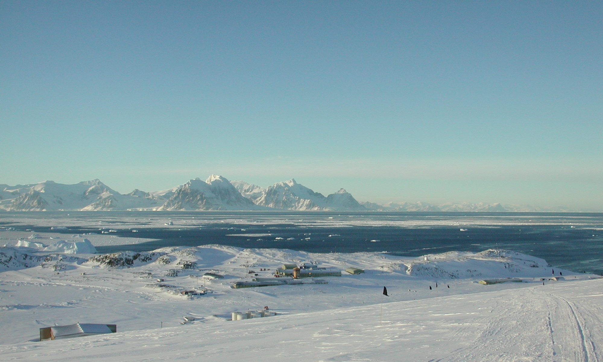
Eight BAS sledgers gathered in the Survey/GA office at Base E early on the morning of 29 Aug 1974 at the start of what was to be the final spring and summer field seasons on the Antarctic Peninsula for dog-team supported scientific parties. That past winter we had been informed by BAS management that Stonington Island Base would close at the end of the 1975 summer work season. Future science operations on the Peninsula would continue during the summer only, using skidoos for transport, with scientific personnel returning to Cambridge for the northern summer months to work up results and formulate plans for upcoming seasons. At 8am, after Tony Gannon returned from a favorable skidoo recce of conditions at the airstrip, all eight of us proceeded up to the dog spans with our P-bags:
Sledge Lima – Roger Scott (Surveyor) and Graham “Genghis” Wright (BC and GA) with the Vikings and Picts
Sledge Oscar – Richard Barrett (Surveyor) and Dog Holden (GA) with the Terrors and Gaels
Sledge Romeo – Bernie Care and Fergy Anckorn (both Geologists) with the Spartans and Komats
Sledge Sierra – Chris Edwards (Geologist) and Chris Knott (GA) with the Ladies and Admirals
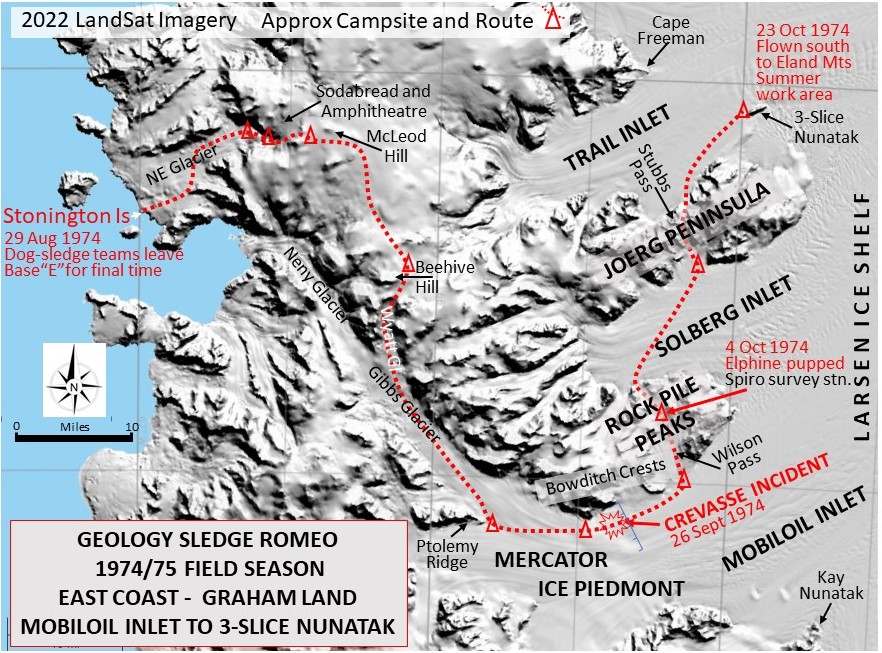
At 10am, after hitching up the dogs to the previously fully loaded sledges, an uneventful trip across the Northeast Glacier via Walton and Butson East saw everyone camped at the foot of Sodabread by 3pm. The next four days were spent ferrying sledge loads up the bottom slope, camping in the Amphitheatre, and recceing a “direct route” up the final slope towards McLeod Hill, with all four sledges established on the Plateau Edge by 2nd Sept.
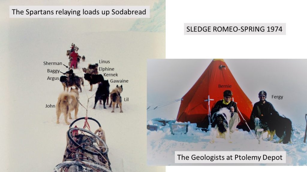
The next day, Sledge Romeo traveled to Beehive Hill where we were forced to lie-up for 4 days due to 30 knot winds, blowing snow and heavy drifting. On 7th Sept, the mank gradually cleared during the morning and by 1pm we had a fast run down the Wyatt Glacier to Sledge Sierra’s campsite and then followed in their tracks down the Gibbs Glacier, catching them up at the Ptolemy Ridge depot where we camped in darkness by 7pm.
Our Spring work programme was to map the geology of Rock Pile Peaks and Joerg Peninsulas, thereby filling in a gap between Stubbs’s work to the north (1964) and Fraser and Grimley’s work to the south (1960-61). A continuous, thick mank cover over the lower elevations of the Mercator Ice Piedmont down to Mobiloil Inlet and the Larsen Ice Shelf to the east, forced us to lie-up for the next two weeks. Conditions at the campsite were manky, snowy and windy during this time, although Ptolemy Ridge afforded good shelter. Needless to say we made a big dent in our reading supply during that fortnight!

Finally on 25th Sept, after several hours spent digging out the campsite and loading the sledges, the Spartans led off with fairly easy going over firm surfaces once we left the soft snow in the lee of Ptolemy. Camped early in thick mank and snow at the top of the slope leading down from the Mercator to the Larsen Ice Shelf. The Komats led off at 10am on the 26th Sept down onto the ice shelf in near white-out conditions using compass bearings to skirt previously recced pressure areas and holes about 1 mile south of the Bowditch Crests. I followed with the Spartans with Lil leading and Elphine moved to second pair as she was in the late stages of pregnancy (resulting from a tryst with Gawaine during the midwinter “jolly” to the Debenham Islands). Conditions were fairly soft, and the Spartans were struggling so I was walking behind the sledge pushing and looking up frequently to see Fergy and the Komats about ½ mile ahead, but I was unable to see their tracks in the near white-out conditions.
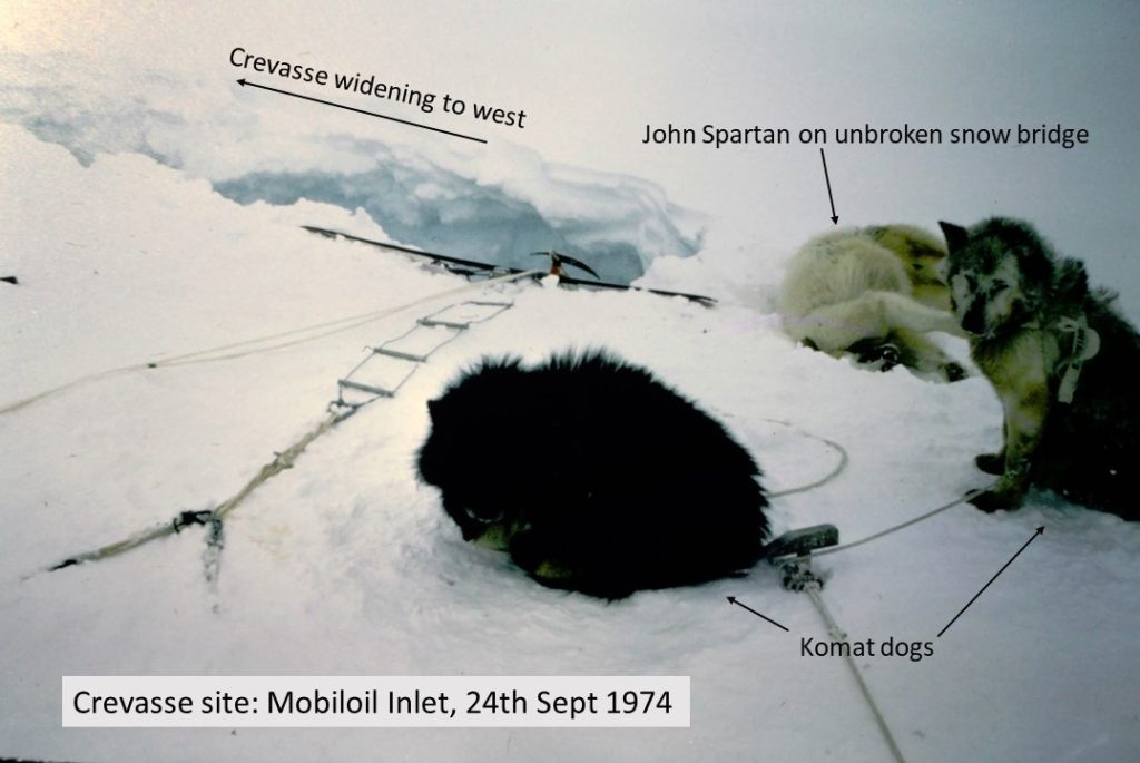
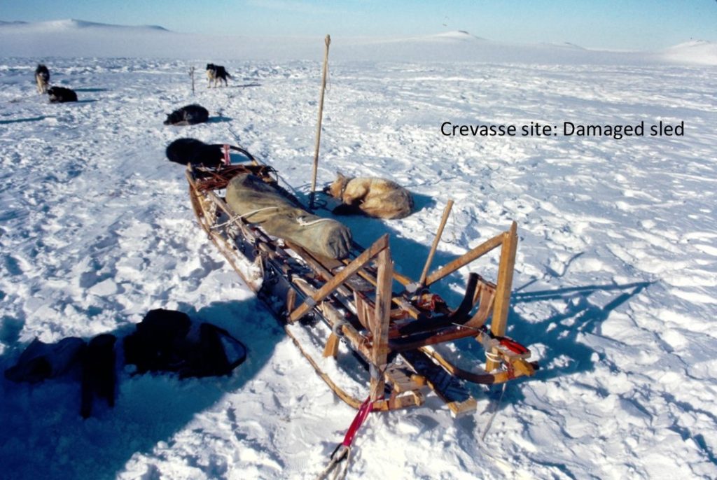
After about 30 minutes I recall hearing a loud “whoompf” and the next thing I remember was lying flat on my back on a collapsed snow bridge which had become wedged about 15 ft to 20 ft down a 3-4 ft wide crevasse. The sledge was on its side with its rear resting on the snow bridge and the cowcatcher suspended by the main trace about 4 ft below the intact snow bridge covering the tapering part of the crevasse. I was lying behind the sledge, and behind me the bridge extended for about 10 ft beyond which the crevasse widened into a bottomless chasm. The dogs had remained on the surface, eerily quiet but unhurt, except for John, the young newcomer to the team, who had been attached by a short trace to the cowcatcher. He had not broken through the snow bridge and had been strangled by his harness as he supported the full weight of the sledge. I had not been able to reach him as I would have had to climb up the sledge to cut him free and risked dislodging the sledge and supporting snow bridge. After gingerly securing myself and the sledge to the side of the crevasse with ice screws I had started to un-lash some of the sledge’s contents when Fergy and the Komats arrived. By 5 pm we had recovered all the gear from the sledge using a Haltrac, and the sledge was lifted to the surface minus crosspieces and handlebar tops although the bed seemed sound.
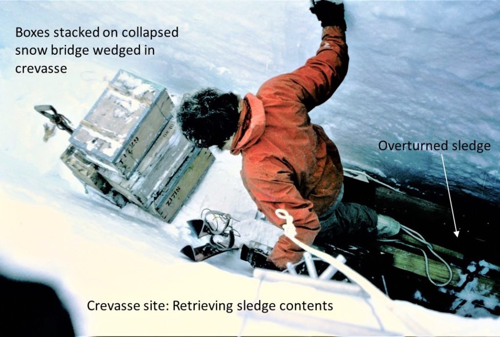
After discussing the day’s events later that evening, we concluded that Lil had strayed from the Komats’ tracks and made a beeline for the team thereby encroaching on the edge of the crevasse field that Fergy had been skirting. The sledge had ended up travelling parallel to and along the edge of a well-bridged crevasse which tapered in the direction of travel. At some point the right-hand sledge runner had broken through the snow bridge causing the bridge to collapse and become wedged in the crevasse about 15 ft down, where it had supported the overturned sledge and driver. I had been attached to the handlebars by a dongle which had kept me close to the back of the sledge and away from the end of the collapsed bridge and the widening crevasse behind me.
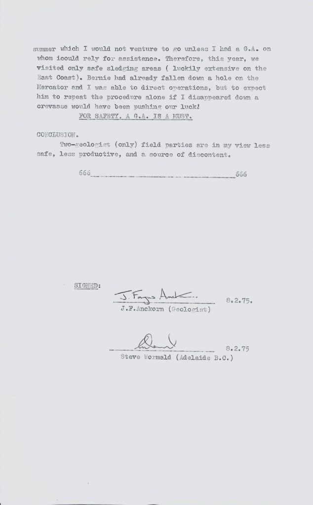
This was the penultimate crevasse incident involving Stonington-based dog teams on the Peninsula. A few days later in early October, the dog Arri from the Admirals (Geology Sledge Sierra) was lost in a crevasse near Carse Point at the northeast end of George VI Sound en route to their Alexander Island work area. Recently I learnt that the deceased dog John of the Spartans was named after John Yates (Stonington surveyor 1972-73), who happened to be best man at my wedding hosted by Steve and Anne Wormald at their Colorado house in June 1991. I also realized that my son’s birthday on 26th September 1996, was exactly 22 years after the incident. Antarctic dog sledge travel for two scientists unaccompanied by a GA is a calculated safety risk even in work areas chosen for their apparent absence of hazards. We were lucky on this occasion just to lose one dog. Fergy’s views on two geologist (only) sledging are reported below.
The next morning, I made temporary repairs to my handlebars and loaded the sledge while Fergy recced the route ahead. We were then visited by the two survey sledges Oscar and Lima. Whilst Lima continued on towards the Kay survey station on the south side of Mobiloil Inlet, we joined forces with Oscar and travelled towards the Spiro survey station on the Rock Pile Peaks Peninsula. Kovik from the 10-dog Gaels was lent to the Spartans for the time being. Following in Lima’s tracks we travelled east along the southern side of Rock Pile Peaks until we reached Vesconte Point and then turned north into Wilson Pass, weaving through numerous 3 to 5 ft wide holes. No accessible rock outcrops were seen during the day and geology was confined to binocular observations. We set up camp on the ice shelf about ½ mile from land ice and spent a mostly sleepless night due to the disturbing sound of creaking ice under the tent coming from deep fissures in the ice shelf which were moving in response to the ocean tides.
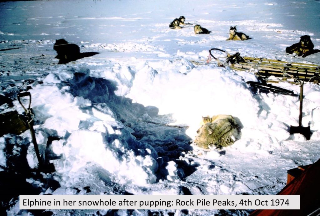
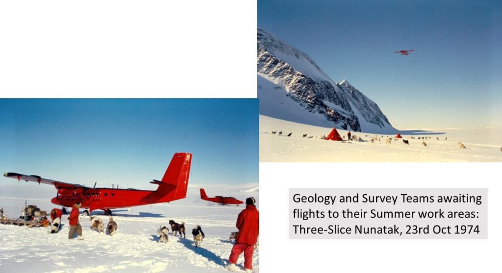
The next day we continued the long climb up the pass in 6-12 ins soft snow conditions to the col by Spiro survey station where we camped in 40-kt winds and drifting snow alongside Sledge Oscar. Poor weather conditions from 29th Sep to 2nd Oct prevented geology or survey work. On the 4th, the snow and mank had cleared sufficiently by the afternoon to allow the surveyors to begin measuring their angles and me to physically examine my first rock exposure for two weeks. Elphine pupped that evening, the 4 dogs and 3 bitches being immediately culled. A lurky breeze the next morning delayed our departure until midday, when under clearing skies we all moved off over the col and down onto Solberg Inlet with the Gaels leading. It was an easy run down this excellent route and little sign of pressure at the edge of the iceshelf. After a bondoo bash over to the bottom of the Hemingway Pass (now called Stubbs Pass) on the Joerg Peninsula we encountered a few open holes about 1 mile out and then camped by 6:30pm in snowy and mank conditions. The next morning Fergy was busy with harness and ski repairs, and I was able to continue “binocular geology” observations in clearing weather, the few rock exposures being again inaccessible and often topped by crumbling icefalls. Kovik was returned to the Gaels that day, as Sledge Oscar travelled north to Cape Freeman to continue the survey programme. On the 7th October Sledge Romeo led by the Komats proceeded up the pass to the col and then down to Trail Inlet through soft snow. After heading out onto the iceshelf for about a mile we swung gradually around and headed for the west end of 3-Slice Nunatak on improving surfaces. With the dogs galloping the last couple of miles much to their drivers’ surprise and with no holes seen on route and only the usual tidal fractures on approaching land-ice, the depot was reached by 6.00pm only to be found buried by 6ft of snow.
The travel report entry for the next fortnight reads simply “Geology of Three Slice Nunatak and awaiting flight south.” I cannot add much to this except that at some point we were re-joined by Survey Sledges Lima and Oscar, and subsequently entertained by the capture of the dog Kovik which had been running free alongside the Gaels team for a few days. This episode is amusingly described in Roger Scott’s account on this website (Stonington 1974).
Eventually VP FAP and VP-FAQ flew in on the 24th October and flew us south to the Eland Mountains to continue Fergy’s work from the previous season, and the survey teams to their Palmer Land traverses.
Bernie Care – Geologist: Stonington 1974/75, Adelaide and Rothera 1975/76 and 1976/77
Bowman Coast Geology Survey Trip statistics
Days in Field 40 days (29 Aug to 7 Oct 1974)
24 days lie-up (60%)
6 days geology (full and partial days) (15%)
10 days travel only (fly in/campsite moves) (25%)
Total sledging distance 120 miles
(Totals do not include 8-24 Oct when we were camped at 3-Slice Nunatak awaiting plane flight to summer work area)
Interim Geology Report – Bernie Care
Special Report on Two-Geologist (only) Sledging – Fergy Anckorn
BAS_FILES\2e_74_g5_(Spring_1974_geology_Bowman_Coast).pdf”
Glad to see Gawaine at least survived the culling of The Rabble at Adelaide early 1974 – and had a little R&R with Elphine during the midwinter “jolly” to the Debenham Islands!
He, together with Tuppence, were my favourites of The Rabble, though all are remembered fondly. I’m 6ft 3in (maybe a little shorter these days?!) yet he could stand on his hind legs and look me in the eye as I gave him a hug. Happy days!